IMAGES TAKEN NEAR TO
Institute Terrace, CROOK, DL15 9TB
Introduction
This page details the photographs taken nearby to Institute Terrace, DL15 9TB by members of the Geograph project.
The Geograph project started in 2005 with the aim of publishing, organising and preserving representative images for every square kilometre of Great Britain, Ireland and the Isle of Man.

There are currently over 7.5m images from over14,400 individuals and you can help contribute to the project by visiting https://www.geograph.org.uk
Image Map
Images are licensed for reuse under creativecommons.org/licenses/by-sa/2.0
Notes
- Clicking on the map will re-center to the selected point.
- The higher the marker number, the further away the image location is from the centre of the postcode.
Image Listing (4 Images Found)
Images are licensed for reuse under creativecommons.org/licenses/by-sa/2.0
Image
Details
Distance
1
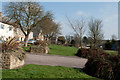
The Green at Billy Row
Billy Row is a village to the north of the small town of Crook in County Durham. Its green is in two parts; the view here is towards the eastern part.
Image: © Trevor Littlewood
Taken: 28 Mar 2011
0.10 miles
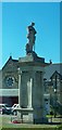
3
No drinking! Temperance Terrace, above Crook.
Image: © Oliver Dixon
Taken: 13 Feb 2007
0.23 miles
4
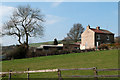
Houses south of Billy Row
An isolated pair of houses seen across a field from the road to Roddymoor.
Image: © Trevor Littlewood
Taken: 28 Mar 2011
0.23 miles