IMAGES TAKEN NEAR TO
West End Villas, CROOK, DL15 9PJ
Introduction
This page details the photographs taken nearby to West End Villas, DL15 9PJ by members of the Geograph project.
The Geograph project started in 2005 with the aim of publishing, organising and preserving representative images for every square kilometre of Great Britain, Ireland and the Isle of Man.

There are currently over 7.5m images from over14,400 individuals and you can help contribute to the project by visiting https://www.geograph.org.uk
Image Map
Images are licensed for reuse under creativecommons.org/licenses/by-sa/2.0
Notes
- Clicking on the map will re-center to the selected point.
- The higher the marker number, the further away the image location is from the centre of the postcode.
Image Listing (8 Images Found)
Images are licensed for reuse under creativecommons.org/licenses/by-sa/2.0
Image
Details
Distance
1
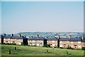
Crook Town
West End Villas with Dow Fold in the distance
Image: © norman griffin
Taken: 10 Sep 1965
0.05 miles
2
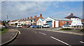
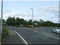
West Road, Crook
Featuring the Prince Bishop Garage, an unusual name.
The Prince Bishops were the powerful part religious, part political officials who more or less ran this part of the country during the middle ages.
Image: © Des Blenkinsopp
Taken: 27 Aug 2022
0.10 miles
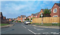
4
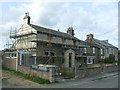
Lax Terrace, West Road, Crook
A slightly unusual name, but that's what the map calls it. The A689 heading west out of Crook.
Image: © Des Blenkinsopp
Taken: 27 Aug 2022
0.11 miles
6
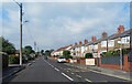
McMillan Drive, Crook
New housing off Peases Way.
Image: © Des Blenkinsopp
Taken: 27 Aug 2022
0.20 miles
7
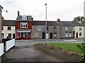
Weardale Veterinary Clinic, Commercial Street, Crook
Image: © Andrew Curtis
Taken: 4 Aug 2018
0.22 miles
8
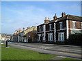
West Croft, Commercial Street, Crook
Image: © Bryan Richardson
Taken: 19 Mar 2005
0.24 miles