IMAGES TAKEN NEAR TO
Uplands Close, CROOK, DL15 9NW
Introduction
This page details the photographs taken nearby to Uplands Close, DL15 9NW by members of the Geograph project.
The Geograph project started in 2005 with the aim of publishing, organising and preserving representative images for every square kilometre of Great Britain, Ireland and the Isle of Man.

There are currently over 7.5m images from over14,400 individuals and you can help contribute to the project by visiting https://www.geograph.org.uk
Image Map
Images are licensed for reuse under creativecommons.org/licenses/by-sa/2.0
Notes
- Clicking on the map will re-center to the selected point.
- The higher the marker number, the further away the image location is from the centre of the postcode.
Image Listing (8 Images Found)
Images are licensed for reuse under creativecommons.org/licenses/by-sa/2.0
Image
Details
Distance
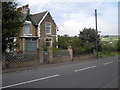
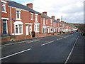
1
Aged Workers Homes (1908), Crook
Retirement homes for coal miners - a common feature of towns in County Durham.
Image: © Oliver Dixon
Taken: 13 Feb 2007
0.09 miles
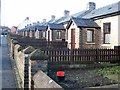
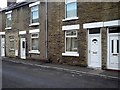
2
Tennyson Terrace, Crook
The light-coloured houses at the far end are Whitwell Terrace.
Image: © Oliver Dixon
Taken: 13 Feb 2007
0.11 miles
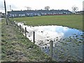
3
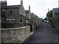
Whitwell Terrace Crook
Rear Access Road
Image: © norman griffin
Taken: 20 Sep 2006
0.12 miles
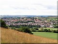
4
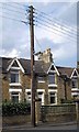
Crook Town
Telegraph Pole Whitwell Terrace
Image: © norman griffin
Taken: 20 Sep 2006
0.12 miles
5
Crook Town
Terrace houses High Hope Street
Image: © norman griffin
Taken: 20 Sep 2006
0.14 miles