IMAGES TAKEN NEAR TO
Victoria Avenue, CROOK, DL15 9DB
Introduction
This page details the photographs taken nearby to Victoria Avenue, DL15 9DB by members of the Geograph project.
The Geograph project started in 2005 with the aim of publishing, organising and preserving representative images for every square kilometre of Great Britain, Ireland and the Isle of Man.

There are currently over 7.5m images from over14,400 individuals and you can help contribute to the project by visiting https://www.geograph.org.uk
Image Map
Images are licensed for reuse under creativecommons.org/licenses/by-sa/2.0
Notes
- Clicking on the map will re-center to the selected point.
- The higher the marker number, the further away the image location is from the centre of the postcode.
Image Listing (27 Images Found)
Images are licensed for reuse under creativecommons.org/licenses/by-sa/2.0
Image
Details
Distance
1
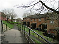
Footpath leading to houses - Crook
A footpath leading down to a row of houses in Crook
Image: © Dylan Chester
Taken: 29 Mar 2021
0.05 miles
2

Crook fire station
Crook fire station, Howe Terrace, Crook, County Durham
Image: © Kevin Hale
Taken: 3 Aug 2010
0.12 miles
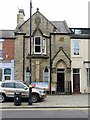
3
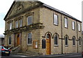
Dawson Street Primitive Methodist Chapel, Crook
Image: © Bryan Richardson
Taken: 3 May 2009
0.18 miles
4
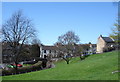
Balaclava, Crook
Areas in the town show historical references
Image: © Bryan Richardson
Taken: 23 Apr 2006
0.19 miles
5
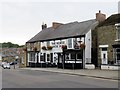
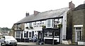
The Horse Shoe Inn, Church Street, Crook
The pub and adjacent former shop front are Grade II Listed Buildings (List entry Number: 1279274) https://www.historicengland.org.uk/listing/the-list/list-entry/1279274
"These former two properties were grade II listed in 1987 and described as ‘late 18th century with mid-19th-century shop and public house fronts. The public house has a door right of centre, with a moulded hood over lintel incised c.1822’. At that time, Crook was a rural hamlet with a population of 228 (125 males; 103 females), chiefly employed in agriculture. The ‘Horse Shoe’ was the only inn."
It is currently owned by J D Wetherspoon.
Image: © Andrew Curtis
Taken: 4 Aug 2018
0.19 miles

10
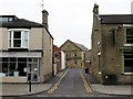
Dawson Street, Crook
Along Dawson Street, just beyond the crossing of Emmerson Street, can be seen the former Primitive Methodist Chapel, named and dated 1868 in pediment. Now the United Reformed Methodist Church. It is a Grade II* Listed Building (List entry Number: 1229012) https://www.historicengland.org.uk/listing/the-list/list-entry/1229012
There is a photo of the chapel here Image
Image: © Andrew Curtis
Taken: 4 Aug 2018
0.21 miles