IMAGES TAKEN NEAR TO
Hollowdene Garth, CROOK, DL15 8LT
Introduction
This page details the photographs taken nearby to Hollowdene Garth, DL15 8LT by members of the Geograph project.
The Geograph project started in 2005 with the aim of publishing, organising and preserving representative images for every square kilometre of Great Britain, Ireland and the Isle of Man.

There are currently over 7.5m images from over14,400 individuals and you can help contribute to the project by visiting https://www.geograph.org.uk
Image Map
Images are licensed for reuse under creativecommons.org/licenses/by-sa/2.0
Notes
- Clicking on the map will re-center to the selected point.
- The higher the marker number, the further away the image location is from the centre of the postcode.
Image Listing (14 Images Found)
Images are licensed for reuse under creativecommons.org/licenses/by-sa/2.0
Image
Details
Distance
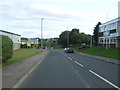
3
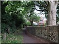
View south down New Road, Crook
As can be seen, this is near the southern edge of the town.
Image: © Robert Graham
Taken: 19 Jun 2015
0.12 miles
4
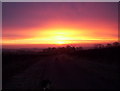
Sunrise over Crook
Taken from Mown Meadows Road.
Image: © Ann Clare
Taken: 5 Jan 2003
0.16 miles
6
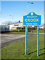
Fat Brewer Brewery
The Fat Brewer Brewery is on the Beechburn Industrial Estate at the southern end of Crook. It's seen beyond a road sign alongside the A689 announcing arrival in Crook; the blue and yellow colouring and style are typical of many found in County Durham.
Image: © Trevor Littlewood
Taken: 15 Feb 2016
0.20 miles
7
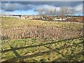
Pond behind Castle Close Industrial Estate, Crook
Note the lonely traffic cone in the pond (right of centre), sharing the same fate as so many of its colleagues up and down the country.
Image: © Oliver Dixon
Taken: 13 Feb 2007
0.20 miles
8
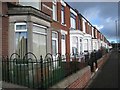
Morson Avenue, Crook
Terraced housing on what was formerly the main road out of Crook to the south before the by-pass was completed in 2004.
Image: © Oliver Dixon
Taken: 13 Feb 2007
0.21 miles
9
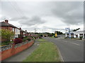
Prospect Road, Crook
Looking south east on the A689.
Image: © JThomas
Taken: 24 Aug 2017
0.21 miles
10
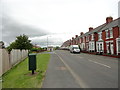
Terrace on New Road, Crook
This road leads south out of the town centre.
Image: © Robert Graham
Taken: 19 Jun 2015
0.21 miles