IMAGES TAKEN NEAR TO
Valley Terrace, CROOK, DL15 8EW
Introduction
This page details the photographs taken nearby to Valley Terrace, DL15 8EW by members of the Geograph project.
The Geograph project started in 2005 with the aim of publishing, organising and preserving representative images for every square kilometre of Great Britain, Ireland and the Isle of Man.

There are currently over 7.5m images from over14,400 individuals and you can help contribute to the project by visiting https://www.geograph.org.uk
Image Map
Images are licensed for reuse under creativecommons.org/licenses/by-sa/2.0
Notes
- Clicking on the map will re-center to the selected point.
- The higher the marker number, the further away the image location is from the centre of the postcode.
Image Listing (12 Images Found)
Images are licensed for reuse under creativecommons.org/licenses/by-sa/2.0
Image
Details
Distance
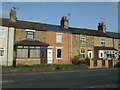
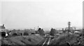
5
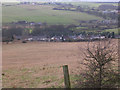
Valley Terrace, Howden-le-Wear
Viewed from North Bitchburn Bank
Image: © Oliver Dixon
Taken: 17 Feb 2006
0.16 miles
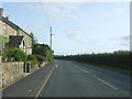
6
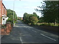
Bridge Street, Howden-le-Wear
Looking south east on the A689.
Image: © JThomas
Taken: 24 Aug 2017
0.19 miles
8
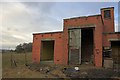
Disused Sub-Station, North Bitchburn Bank
Image: © Mick Garratt
Taken: 15 Mar 2010
0.20 miles
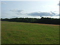
9
Beechburn Station (remains)
View southward, towards Bishop Auckland; Darlington - Bishop Auckland - Crook - Tow Law line. Station closed with line Bishop Auckland - Crook (Crook - Tow Law had been closed 11/6/56).
Image: © Ben Brooksbank
Taken: 10 May 1965
0.22 miles
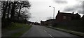
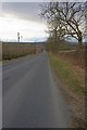
10
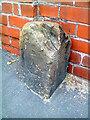
Old Bridge Marker by the A689, Bridge Street, Howden-le-Wear
Bridge Marker by the A689, in parish of Crook (Wear Valley District), Northwest of Eels Nook Bridge, Beechburn Beck, against garden wall of house in Bridge Street, Howden-le-Wear.
Surveyed
Milestone Society National ID: DU_CROOK01br
Image: © Milestone Society
Taken: 13 Sep 2018
0.22 miles