IMAGES TAKEN NEAR TO
Fir Tree, CROOK, DL15 8DS
Introduction
This page details the photographs taken nearby to DL15 8DS by members of the Geograph project.
The Geograph project started in 2005 with the aim of publishing, organising and preserving representative images for every square kilometre of Great Britain, Ireland and the Isle of Man.

There are currently over 7.5m images from over14,400 individuals and you can help contribute to the project by visiting https://www.geograph.org.uk
Image Map
Images are licensed for reuse under creativecommons.org/licenses/by-sa/2.0
Notes
- Clicking on the map will re-center to the selected point.
- The higher the marker number, the further away the image location is from the centre of the postcode.
Image Listing (6 Images Found)
Images are licensed for reuse under creativecommons.org/licenses/by-sa/2.0
Image
Details
Distance
1
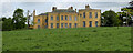
Harperley Hall
Built in 1790 by Marmaduke Craddock, moving from the original manor house at Low Harperley Farm.
Now is the College of Policing's Forensic Centre.
Passed by on the Weardale Way long distance footpath.
Image: © Chris Heaton
Taken: 20 May 2022
0.05 miles
2
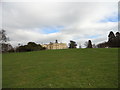
Harperley Hall
Large former manor house built in the late 18th century.
The composer John Garth (1721-1810) was born here. See https://en.wikipedia.org/wiki/John_Garth_(composer)
Image: © Robert Graham
Taken: 21 Mar 2012
0.08 miles
3
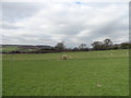
Stile on the Weardale Way
Located in the field in front of Harperley Hall. The way is a bit difficult to follow along this section, not being clearly defined. There are extensive views to the East down the Wear valley.
Image: © Robert Graham
Taken: 21 Mar 2012
0.14 miles
4
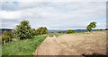
Field with sparsely growing crop
The field lies to the west of Mount Plantation; a public footpath follows the overgrown edge to the left.
Image: © Trevor Littlewood
Taken: 13 May 2020
0.20 miles
5
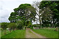
Large sycamore
On the track to Low Harperley
Image: © Tim Heaton
Taken: 20 May 2022
0.22 miles
6
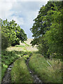
Farm road climbing past small plantation
The road is also the route of a public footpath between two farms: Low Harperley and Black Hall. Trees of the small, Fish Pond Plantation are at the right side of the image.
Image: © Trevor Littlewood
Taken: 26 Aug 2023
0.24 miles