IMAGES TAKEN NEAR TO
Hazel Grove Terrace, CROOK, DL15 8DF
Introduction
This page details the photographs taken nearby to Hazel Grove Terrace, DL15 8DF by members of the Geograph project.
The Geograph project started in 2005 with the aim of publishing, organising and preserving representative images for every square kilometre of Great Britain, Ireland and the Isle of Man.

There are currently over 7.5m images from over14,400 individuals and you can help contribute to the project by visiting https://www.geograph.org.uk
Image Map
Images are licensed for reuse under creativecommons.org/licenses/by-sa/2.0
Notes
- Clicking on the map will re-center to the selected point.
- The higher the marker number, the further away the image location is from the centre of the postcode.
Image Listing (21 Images Found)
Images are licensed for reuse under creativecommons.org/licenses/by-sa/2.0
Image
Details
Distance
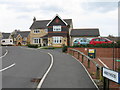
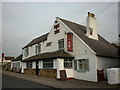
2
The Duke of York public house, Fir Tree
On the A68.
Image: © JThomas
Taken: 18 Jun 2018
0.04 miles
3
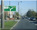
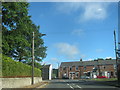
Approaching a dogleg bend in the A68 at Fir Tree
And a road off left to Howden-le-Wear.
Image: © Stanley Howe
Taken: 22 May 2012
0.04 miles
6
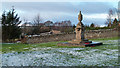
War memorial at Fir Tree
Fir Tree is a small village on the A68; its war memorial sits on a green at its west side.
Image: © Trevor Littlewood
Taken: 17 Dec 2011
0.04 miles
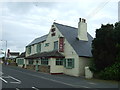
7
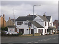
Duke of York Inn, Fir Tree
On the A68. Features in the Egon Ronay guide.
Image: © Oliver Dixon
Taken: 17 Feb 2006
0.05 miles
8

Sign for the Duke of York public house, Fir Tree
Image: © JThomas
Taken: 18 Jun 2018
0.06 miles
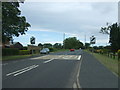
10
The A68 about to turn sharp left in Fir Tree
Image: © Peter Robinson
Taken: 18 Sep 2013
0.12 miles