IMAGES TAKEN NEAR TO
Railway Cottages, CROOK, DL15 8BA
Introduction
This page details the photographs taken nearby to Railway Cottages, DL15 8BA by members of the Geograph project.
The Geograph project started in 2005 with the aim of publishing, organising and preserving representative images for every square kilometre of Great Britain, Ireland and the Isle of Man.

There are currently over 7.5m images from over14,400 individuals and you can help contribute to the project by visiting https://www.geograph.org.uk
Image Map
Images are licensed for reuse under creativecommons.org/licenses/by-sa/2.0
Notes
- Clicking on the map will re-center to the selected point.
- The higher the marker number, the further away the image location is from the centre of the postcode.
Image Listing (17 Images Found)
Images are licensed for reuse under creativecommons.org/licenses/by-sa/2.0
Image
Details
Distance

2
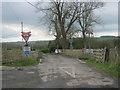
Level crossing over the Weardale Railway for access to Enginemans Terrace
Image: © Peter Robinson
Taken: 22 Apr 2012
0.07 miles
3
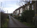
Enginemans Terrace
Off Low Lane. Near disused Slotburn Brickworks (1890's-1960's). On the old Darlington & Consett Branch Line.
Image: © Hugh Mortimer
Taken: 6 Jan 2007
0.12 miles
4
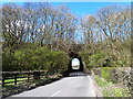
Slotburn Bridge over Low Lane
The Weardale heritage railway crosses the floodplain of the River Wear on a high embankment.
Image: © Oliver Dixon
Taken: 11 Apr 2014
0.14 miles
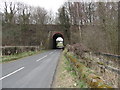
5
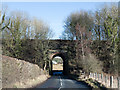
Railway bridge over Low Lane
The bridge carries the rail route between Bishop Auckland and the Wear valley which operates as a 'heritage line'. The bridge is a high one and the extent of road covered by it gives almost the impression of there being a short tunnel.
Image: © Trevor Littlewood
Taken: 9 Feb 2018
0.15 miles
6
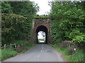
Railway bridge over Low Lane
Used by the Weardale Railway.
Looking west.
Image: © JThomas
Taken: 18 Jun 2018
0.15 miles
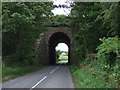
7
Slotburn Bridge
Bridge for the Weardale Railway over Low Lane.
Image: © Robert Graham
Taken: 21 Mar 2012
0.15 miles
8
Railway bridge over Low Lane
Used by the Weardale Railway.
Looking east.
Image: © JThomas
Taken: 18 Jun 2018
0.15 miles
9
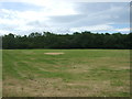
Cut silage field, Slotburn Bridge
Off Low Lane.
Image: © JThomas
Taken: 18 Jun 2018
0.17 miles
10
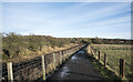
Path beside Weardale Railway
The path seen here is on the south side of the railway, to the north of Low Lane and the Low Barns nature reserve. The heritage railway has seen little action in recent years and this year even the Santa Specials haven't run due to the Covid 19 epidemic.
Image: © Trevor Littlewood
Taken: 25 Dec 2020
0.18 miles