IMAGES TAKEN NEAR TO
High Grange, CROOK, DL15 8AZ
Introduction
This page details the photographs taken nearby to High Grange, DL15 8AZ by members of the Geograph project.
The Geograph project started in 2005 with the aim of publishing, organising and preserving representative images for every square kilometre of Great Britain, Ireland and the Isle of Man.

There are currently over 7.5m images from over14,400 individuals and you can help contribute to the project by visiting https://www.geograph.org.uk
Image Map
Images are licensed for reuse under creativecommons.org/licenses/by-sa/2.0
Notes
- Clicking on the map will re-center to the selected point.
- The higher the marker number, the further away the image location is from the centre of the postcode.
Image Listing (15 Images Found)
Images are licensed for reuse under creativecommons.org/licenses/by-sa/2.0
Image
Details
Distance
1
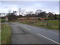
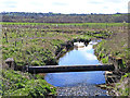
Beechburn Bridge
Bridge over Beechburn Beck, right up Grange Bank to the A684, left to Witton-le-Wear
Image: © Hugh Mortimer
Taken: 7 Jan 2007
0.03 miles
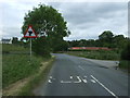
3
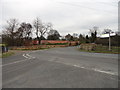
Beechburn crossroads
Crossroads on Low Lane near High Grange.
Image: © Robert Graham
Taken: 21 Mar 2012
0.04 miles
4
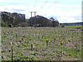
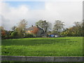
Tree planting at Beechburn Farm
The saplings are protected by Tuley tubes.
Image: © Oliver Dixon
Taken: 11 Apr 2014
0.05 miles
5
Beechburn Beck
The village of Witton Park can be seen on the far hillside.
Image: © Oliver Dixon
Taken: 11 Apr 2014
0.05 miles
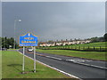
6
Road junction on National Cycle Route 70
Looking north.
Image: © JThomas
Taken: 18 Jun 2018
0.05 miles
7
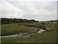
Beechburn Beck
Little stream which runs through the fields at Beechburn Bridge.
Image: © Robert Graham
Taken: 21 Mar 2012
0.08 miles
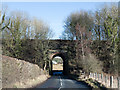
9
Railway bridge over Low Lane
Used by the Weardale Railway.
Looking west.
Image: © JThomas
Taken: 18 Jun 2018
0.21 miles
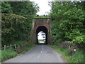
10
Railway bridge over Low Lane
The bridge carries the rail route between Bishop Auckland and the Wear valley which operates as a 'heritage line'. The bridge is a high one and the extent of road covered by it gives almost the impression of there being a short tunnel.
Image: © Trevor Littlewood
Taken: 9 Feb 2018
0.22 miles