IMAGES TAKEN NEAR TO
High Grange, CROOK, DL15 8AS
Introduction
This page details the photographs taken nearby to High Grange, DL15 8AS by members of the Geograph project.
The Geograph project started in 2005 with the aim of publishing, organising and preserving representative images for every square kilometre of Great Britain, Ireland and the Isle of Man.

There are currently over 7.5m images from over14,400 individuals and you can help contribute to the project by visiting https://www.geograph.org.uk
Image Map
Images are licensed for reuse under creativecommons.org/licenses/by-sa/2.0
Notes
- Clicking on the map will re-center to the selected point.
- The higher the marker number, the further away the image location is from the centre of the postcode.
Image Listing (12 Images Found)
Images are licensed for reuse under creativecommons.org/licenses/by-sa/2.0
Image
Details
Distance
1
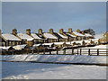
Houses in High Grange, County Durham
High Grange is a small village in County Durham bypassed by the A689, lying between Crook and Bishop Auckland.
Image: © Trevor Littlewood
Taken: 6 Dec 2010
0.02 miles
2
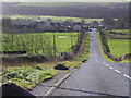
Green Lane : High Grange
High Grange on the A689. A small ex-mining village, which previously had a school and mission hall.
Image: © Hugh Mortimer
Taken: 21 Jan 2007
0.03 miles
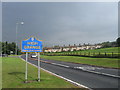
3
Terraced housing at High Grange
High Grange is a small settlement between Crook and Bishop Auckland in County Durham; it's bypassed by the A689 as seen in the photograph. The blue and yellow road sign signalling arrival at High Grange is in a style commonly found in County Durham.
Image: © Trevor Littlewood
Taken: 18 Feb 2014
0.05 miles
5
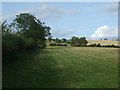
Grazing and hedgerow, High Grange
A footpath runs beside the hedge.
Image: © JThomas
Taken: 24 Aug 2017
0.15 miles
7
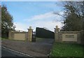
Entrance to Small Leazes Farm from Green Lane
Image: © Peter Robinson
Taken: 27 Oct 2013
0.18 miles
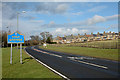
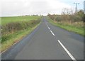
8

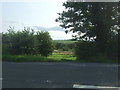
A689 towards Bishop Auckland
Looking south east.
Image: © JThomas
Taken: 24 Aug 2017
0.21 miles
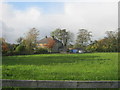
10
Green Lane rising up from High Grange
Image: © Peter Robinson
Taken: 27 Oct 2013
0.23 miles