IMAGES TAKEN NEAR TO
North Bitchburn, CROOK, DL15 8AN
Introduction
This page details the photographs taken nearby to DL15 8AN by members of the Geograph project.
The Geograph project started in 2005 with the aim of publishing, organising and preserving representative images for every square kilometre of Great Britain, Ireland and the Isle of Man.

There are currently over 7.5m images from over14,400 individuals and you can help contribute to the project by visiting https://www.geograph.org.uk
Image Map
Images are licensed for reuse under creativecommons.org/licenses/by-sa/2.0
Notes
- Clicking on the map will re-center to the selected point.
- The higher the marker number, the further away the image location is from the centre of the postcode.
Image Listing (7 Images Found)
Images are licensed for reuse under creativecommons.org/licenses/by-sa/2.0
Image
Details
Distance
1
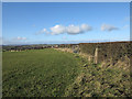
Roadside hedge with trig point
The trig point is known to the OS as High House and is in a field beside the minor road south-east from the small settlement at North Bitchburn.
Image: © Trevor Littlewood
Taken: 12 Nov 2013
0.15 miles
2
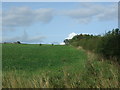
Farmland and hedgerow near North Bitchburn
Off the A689.
Image: © JThomas
Taken: 24 Aug 2017
0.19 miles
3
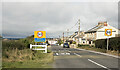
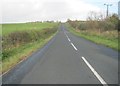
Minor road entering North Bitchburn
North Bitchburn is a small settlement in County Durham. The road sign announcing arrival in the village is in a style and colours typical in the county; often as here, they're incorporated into the speed limit alert.
Image: © Trevor Littlewood
Taken: 24 Sep 2021
0.19 miles
5
Green Lane rising up from High Grange
Image: © Peter Robinson
Taken: 27 Oct 2013
0.21 miles
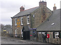
6
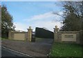
Entrance to Small Leazes Farm from Green Lane
Image: © Peter Robinson
Taken: 27 Oct 2013
0.22 miles
7
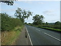
A689 towards Bishop Auckland
Looking south east.
Image: © JThomas
Taken: 24 Aug 2017
0.25 miles