IMAGES TAKEN NEAR TO
North Lane, CROOK, DL15 0TZ
Introduction
This page details the photographs taken nearby to North Lane, DL15 0TZ by members of the Geograph project.
The Geograph project started in 2005 with the aim of publishing, organising and preserving representative images for every square kilometre of Great Britain, Ireland and the Isle of Man.

There are currently over 7.5m images from over14,400 individuals and you can help contribute to the project by visiting https://www.geograph.org.uk
Image Map
Images are licensed for reuse under creativecommons.org/licenses/by-sa/2.0
Notes
- Clicking on the map will re-center to the selected point.
- The higher the marker number, the further away the image location is from the centre of the postcode.
Image Listing (4 Images Found)
Images are licensed for reuse under creativecommons.org/licenses/by-sa/2.0
Image
Details
Distance
1
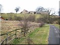
Stonechester
At the top of a steep bluff, Stonechester is approached from the road beyond the top of the hill. The access road in the foreground leads to Northwood House (just visible on the left hand edge of the picture).
Image: © Oliver Dixon
Taken: 13 Feb 2007
0.01 miles
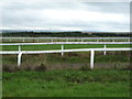
3
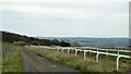
Gallops at Stonechester
At this point running parallel to North Lane (out of view to the left)
Image: © Kevin Waterhouse
Taken: 16 Apr 2023
0.19 miles