IMAGES TAKEN NEAR TO
Stockley Lane, CROOK, DL15 0TQ
Introduction
This page details the photographs taken nearby to Stockley Lane, DL15 0TQ by members of the Geograph project.
The Geograph project started in 2005 with the aim of publishing, organising and preserving representative images for every square kilometre of Great Britain, Ireland and the Isle of Man.

There are currently over 7.5m images from over14,400 individuals and you can help contribute to the project by visiting https://www.geograph.org.uk
Image Map
Images are licensed for reuse under creativecommons.org/licenses/by-sa/2.0
Notes
- Clicking on the map will re-center to the selected point.
- The higher the marker number, the further away the image location is from the centre of the postcode.
Image Listing (2 Images Found)
Images are licensed for reuse under creativecommons.org/licenses/by-sa/2.0
Image
Details
Distance
1
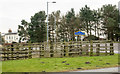
Animal pens at road junction
The wooden fencing forms the animal pens - there were sheep there at the time the image was recorded.
Beyond the pens is a typical blue and yellow road sign telling that the old 'pit village' of Oakenshaw is being reached. Beyond that is a bus turning area and car park.
Image: © Trevor Littlewood
Taken: 26 Feb 2016
0.03 miles
2
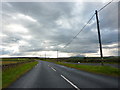
Stockley Lane west of Oakenshaw Farm
Image: © Alexander P Kapp
Taken: 24 Aug 2011
0.17 miles