IMAGES TAKEN NEAR TO
Hunwick, CROOK, DL15 0RQ
Introduction
This page details the photographs taken nearby to DL15 0RQ by members of the Geograph project.
The Geograph project started in 2005 with the aim of publishing, organising and preserving representative images for every square kilometre of Great Britain, Ireland and the Isle of Man.

There are currently over 7.5m images from over14,400 individuals and you can help contribute to the project by visiting https://www.geograph.org.uk
Image Map
Images are licensed for reuse under creativecommons.org/licenses/by-sa/2.0
Notes
- Clicking on the map will re-center to the selected point.
- The higher the marker number, the further away the image location is from the centre of the postcode.
Image Listing (5 Images Found)
Images are licensed for reuse under creativecommons.org/licenses/by-sa/2.0
Image
Details
Distance
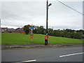
3
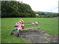
Scarecrow on bench, Front Street, New Hunwick
Part of the Hunwick Show 2018.
Image: © JThomas
Taken: 27 Aug 2018
0.23 miles
4
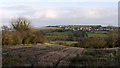
Field east of Brandon - Bishop Auckland Walk
The Brandon to Bishop Auckland Walk follows an old railway route. The view is to the east over a stubble field with the village of Newfield to be seen across the valley of the River Wear.
Image: © Trevor Littlewood
Taken: 7 Jan 2012
0.23 miles
5
Guardsman scarecrow on Front Street, New Hunwick
Part of the Hunwick Show 2018.
Image: © JThomas
Taken: 27 Aug 2018
0.24 miles