IMAGES TAKEN NEAR TO
Denewood Close, CROOK, DL15 0HB
Introduction
This page details the photographs taken nearby to Denewood Close, DL15 0HB by members of the Geograph project.
The Geograph project started in 2005 with the aim of publishing, organising and preserving representative images for every square kilometre of Great Britain, Ireland and the Isle of Man.

There are currently over 7.5m images from over14,400 individuals and you can help contribute to the project by visiting https://www.geograph.org.uk
Image Map
Images are licensed for reuse under creativecommons.org/licenses/by-sa/2.0
Notes
- Clicking on the map will re-center to the selected point.
- The higher the marker number, the further away the image location is from the centre of the postcode.
Image Listing (22 Images Found)
Images are licensed for reuse under creativecommons.org/licenses/by-sa/2.0
Image
Details
Distance
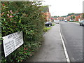
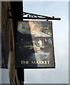
5
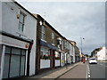
Greater Willington Town Council
On High Street (A690), Willington.
houses in the former Market public house.
Image: © JThomas
Taken: 27 Aug 2018
0.15 miles
6
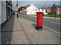
High Street, Willington
Showing position Postbox No. DL15 188.
See Image] for postbox.
Image: © JThomas
Taken: 27 Aug 2018
0.15 miles
7
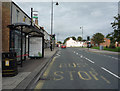
Bus stop and shelter on High Street (A690), Willington
Image: © JThomas
Taken: 27 Aug 2018
0.15 miles
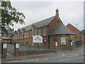
8
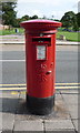
Elizabeth II postbox on High Street, Willington
Postbox No. DL15 188.
See Image] for context.
Image: © JThomas
Taken: 27 Aug 2018
0.15 miles
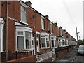
10
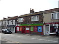
Post Office and convenience store on High Street (A690), Willington
Image: © JThomas
Taken: 27 Aug 2018
0.16 miles