IMAGES TAKEN NEAR TO
Ullswater Avenue, DARLINGTON, DL1 4TF
Introduction
This page details the photographs taken nearby to Ullswater Avenue, DL1 4TF by members of the Geograph project.
The Geograph project started in 2005 with the aim of publishing, organising and preserving representative images for every square kilometre of Great Britain, Ireland and the Isle of Man.

There are currently over 7.5m images from over14,400 individuals and you can help contribute to the project by visiting https://www.geograph.org.uk
Image Map
Images are licensed for reuse under creativecommons.org/licenses/by-sa/2.0
Notes
- Clicking on the map will re-center to the selected point.
- The higher the marker number, the further away the image location is from the centre of the postcode.
Image Listing (89 Images Found)
Images are licensed for reuse under creativecommons.org/licenses/by-sa/2.0
Image
Details
Distance
1
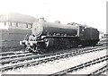
Former LNER class K1, 62005 passes Darlington (South) signal box
Image: © Roger Cornfoot
Taken: Unknown
0.09 miles
2
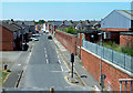
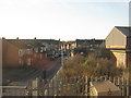
Henderson Street
Viewed on the approach to Darlington Station.
Image: © Mary and Angus Hogg
Taken: 29 Jun 2018
0.10 miles

4
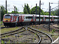
Virgin train at Darlington railway station
HST number 43313 heading south from Platform 1.
Image: © Thomas Nugent
Taken: 3 Jun 2017
0.12 miles
5
Virgin train at Darlington railway station
HST number 43313 heading south from Platform 1.
Image: © Thomas Nugent
Taken: 3 Jun 2017
0.12 miles
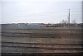
6
Smithfield Road, Darlington
Housing and a small industrial site just south of Darlington station.
Image: © M J Richardson
Taken: 18 Nov 2019
0.12 miles
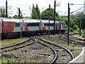
7
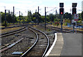
Darlington railway station
Tracks at the south end of the station.
Image: © Thomas Nugent
Taken: 29 Aug 2016
0.12 miles

10
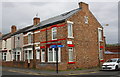
Junction of Park Lane and Smithfield Road
There is an OS benchmark Image on the corner of the nearest house, right hand face, at the junction of the house and its front side boundary wall
Image: © Roger Templeman
Taken: 9 Sep 2016
0.13 miles