IMAGES TAKEN NEAR TO
Moorfield Close, DARLINGTON, DL1 4RX
Introduction
This page details the photographs taken nearby to Moorfield Close, DL1 4RX by members of the Geograph project.
The Geograph project started in 2005 with the aim of publishing, organising and preserving representative images for every square kilometre of Great Britain, Ireland and the Isle of Man.

There are currently over 7.5m images from over14,400 individuals and you can help contribute to the project by visiting https://www.geograph.org.uk
Image Map
Images are licensed for reuse under creativecommons.org/licenses/by-sa/2.0
Notes
- Clicking on the map will re-center to the selected point.
- The higher the marker number, the further away the image location is from the centre of the postcode.
Image Listing (2 Images Found)
Images are licensed for reuse under creativecommons.org/licenses/by-sa/2.0
Image
Details
Distance
1
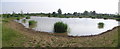
Maidendale : Nature Reserve
A series of ponds on former wasteground between Firth Moor Estate and Salters Lane.
Image: © Hugh Mortimer
Taken: 3 Jul 2006
0.23 miles
2

Housing, Firth Moor, Darlington
Housing estate with a clutch of new houses on a previous vacant strip of land beside the Darlington - Middlesbrough railway line.
Image: © David Robinson
Taken: 24 Jan 2019
0.25 miles