IMAGES TAKEN NEAR TO
Hirst Grove, DARLINGTON, DL1 4NX
Introduction
This page details the photographs taken nearby to Hirst Grove, DL1 4NX by members of the Geograph project.
The Geograph project started in 2005 with the aim of publishing, organising and preserving representative images for every square kilometre of Great Britain, Ireland and the Isle of Man.

There are currently over 7.5m images from over14,400 individuals and you can help contribute to the project by visiting https://www.geograph.org.uk
Image Map
Images are licensed for reuse under creativecommons.org/licenses/by-sa/2.0
Notes
- Clicking on the map will re-center to the selected point.
- The higher the marker number, the further away the image location is from the centre of the postcode.
Image Listing (6 Images Found)
Images are licensed for reuse under creativecommons.org/licenses/by-sa/2.0
Image
Details
Distance

4
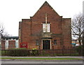
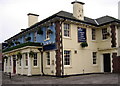
St Herbert's Church
Yarm Road, Darlington. Not exactly a well known saint Herbert was a hermit and friend of St. Cuthbert. He lived as a recluse on an island in Lake Derwentwater which became St. Herbert’s in his honour.
Image: © Alan Fearon
Taken: 16 Feb 2006
0.17 miles
5
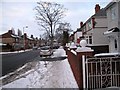
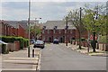
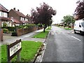
Geneva Road, Darlington
Geneva Road is a typical suburban area of Darlington. The road itself provides a link between Neasham Road and the B6280 (Yarm Road). This photograph shows the section of Geneva Road near to its junction with Yarm Road. The picture was taken after a fall of snow in early January looking in a northerly direction towards the junction at Yarm Road.
Image: © Philip Barker
Taken: 10 Jan 2010
0.17 miles