IMAGES TAKEN NEAR TO
Brunton Street, DARLINGTON, DL1 4EL
Introduction
This page details the photographs taken nearby to Brunton Street, DL1 4EL by members of the Geograph project.
The Geograph project started in 2005 with the aim of publishing, organising and preserving representative images for every square kilometre of Great Britain, Ireland and the Isle of Man.

There are currently over 7.5m images from over14,400 individuals and you can help contribute to the project by visiting https://www.geograph.org.uk
Image Map
Images are licensed for reuse under creativecommons.org/licenses/by-sa/2.0
Notes
- Clicking on the map will re-center to the selected point.
- The higher the marker number, the further away the image location is from the centre of the postcode.
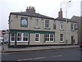
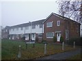
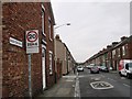
Image Listing (32 Images Found)
Images are licensed for reuse under creativecommons.org/licenses/by-sa/2.0
Image
Details
Distance
4
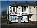
Lally's
News & Off Licence on Yarm Road, Darlington
Image: © Richard Croft
Taken: 30 Mar 2012
0.17 miles
8
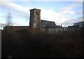
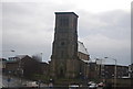
Church of St John the Evangelist, Darlington
Its tower seen from an express train on the through line past Bank Top station.
Image: © Stanley Howe
Taken: 18 Jan 2010
0.19 miles
9
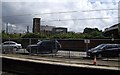
View across East Coast Main Line outside Bank Top Station
Viewed from Pensbury Lane.
Image: © Stanley Howe
Taken: 14 Aug 2010
0.19 miles