IMAGES TAKEN NEAR TO
Starmer Crescent, DARLINGTON, DL1 4DG
Introduction
This page details the photographs taken nearby to Starmer Crescent, DL1 4DG by members of the Geograph project.
The Geograph project started in 2005 with the aim of publishing, organising and preserving representative images for every square kilometre of Great Britain, Ireland and the Isle of Man.

There are currently over 7.5m images from over14,400 individuals and you can help contribute to the project by visiting https://www.geograph.org.uk
Image Map
Images are licensed for reuse under creativecommons.org/licenses/by-sa/2.0
Notes
- Clicking on the map will re-center to the selected point.
- The higher the marker number, the further away the image location is from the centre of the postcode.
Image Listing (6 Images Found)
Images are licensed for reuse under creativecommons.org/licenses/by-sa/2.0
Image
Details
Distance
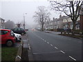
1
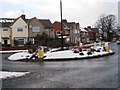
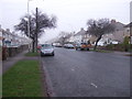
Roundabout on Neasham Road
This photograph shows a roundabout at the inter-section of Neasham Road, Geneva Road and Parkside. The photograph was taken looking along Neasham Road in a north-north-westerly direction towards the centre of Darlington. Geneva Road lies to the right and Parkside goes off to the left of the roundabout.
Image: © Philip Barker
Taken: 10 Jan 2010
0.10 miles
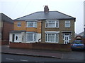
4

The Copper Beech Pub
Neasham Road, Darlington. A few branches of the real beech just get into the picture.
Image: © Alan Fearon
Taken: 16 Feb 2006
0.14 miles