IMAGES TAKEN NEAR TO
Maben Avenue, BISHOP AUCKLAND, DL14 9DQ
Introduction
This page details the photographs taken nearby to Maben Avenue, DL14 9DQ by members of the Geograph project.
The Geograph project started in 2005 with the aim of publishing, organising and preserving representative images for every square kilometre of Great Britain, Ireland and the Isle of Man.

There are currently over 7.5m images from over14,400 individuals and you can help contribute to the project by visiting https://www.geograph.org.uk
Image Map
Images are licensed for reuse under creativecommons.org/licenses/by-sa/2.0
Notes
- Clicking on the map will re-center to the selected point.
- The higher the marker number, the further away the image location is from the centre of the postcode.
Image Listing (23 Images Found)
Images are licensed for reuse under creativecommons.org/licenses/by-sa/2.0
Image
Details
Distance
1
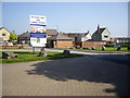
Access to Housing Estates
Off Woodhouse Lane, St Helen Auckland.
Image: © Stanley Howe
Taken: 23 May 2012
0.03 miles
2
Lane and Path to Woodhouse Farm
From near St Helen Auckland churchyard.
Image: © Stanley Howe
Taken: 23 May 2012
0.04 miles
3
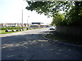
Woodhouse Lane, St Helen Auckland
The building at the end of the lane is St Helen's Parish Centre. See https://web.archive.org/web/20080703154041/http://www.sthelenscouts.co.uk/church/Parish%20Centre.htm
Image: © Stanley Howe
Taken: 23 May 2012
0.07 miles
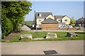
5
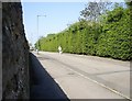
A 'back-street' in St Helen Auckland
Vehicular entrance from Woodhouse Lane is blocked but pedestrians may pass. Traffic from the far end is only allowed to proceed this far. The wall on the left is the rear of St Helen's churchyard. The hedge on the right is the boundary of a playing field.
Image: © Stanley Howe
Taken: 23 May 2012
0.08 miles
6
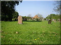
View over the graveyard wall
From Woodhouse Lane towards the School at St Helen's. As is common these days a lot of damaged grave furniture seems to have been cleared from this end of the old graveyard to facilitate grasscutting and general ease of maintenance.
Image: © Stanley Howe
Taken: 23 May 2012
0.10 miles
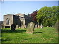
7
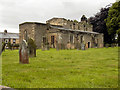
Graveyard at St. Helen's Church
The eastern side of the graveyard is in view. The church is grade 1 listed and dates from the late 12th. century.
Image: © Trevor Littlewood
Taken: 13 Dec 2022
0.11 miles
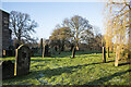
8
Old gravestones
Close to the church in St Helen's Churchyard.
Image: © Stanley Howe
Taken: 23 May 2012
0.11 miles
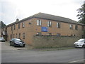
10
St. Helen's Auckland Church
Details of this ancient church can be found at https://web.archive.org/web/20080516061743/http://www.sthelenscouts.co.uk/church/history.htm
Image: © Neville Davison
Taken: 18 Dec 2008
0.12 miles