IMAGES TAKEN NEAR TO
The Oval, BISHOP AUCKLAND, DL14 9DB
Introduction
This page details the photographs taken nearby to The Oval, DL14 9DB by members of the Geograph project.
The Geograph project started in 2005 with the aim of publishing, organising and preserving representative images for every square kilometre of Great Britain, Ireland and the Isle of Man.

There are currently over 7.5m images from over14,400 individuals and you can help contribute to the project by visiting https://www.geograph.org.uk
Image Map
Images are licensed for reuse under creativecommons.org/licenses/by-sa/2.0
Notes
- Clicking on the map will re-center to the selected point.
- The higher the marker number, the further away the image location is from the centre of the postcode.
Image Listing (5 Images Found)
Images are licensed for reuse under creativecommons.org/licenses/by-sa/2.0
Image
Details
Distance
1
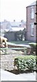
Aged Miners' Homes, St Helen Auckland
A short terrace of 3-roomed homes for retired miners, with vest-pocket front gardens.
Image: © Stanley Howe
Taken: 20 Apr 1971
0.09 miles
2
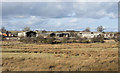
Derelict industrial buildings
The buildings are on an industrial estate at St. Helen Auckland; they're seen from the A688 which bypasses the village as well as the neighbouring West Auckland and the town of Bishop Auckland.
Image: © Trevor Littlewood
Taken: 27 Feb 2015
0.20 miles
4
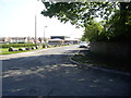
Woodhouse Lane, St Helen Auckland
The building at the end of the lane is St Helen's Parish Centre. See https://web.archive.org/web/20080703154041/http://www.sthelenscouts.co.uk/church/Parish%20Centre.htm
Image: © Stanley Howe
Taken: 23 May 2012
0.23 miles
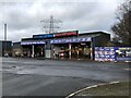
5
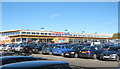
Tesco Extra at Tindale Crescent
Seen on opening day
Image: © Peter Robinson
Taken: 25 Oct 2010
0.24 miles