IMAGES TAKEN NEAR TO
Wilson Street, BISHOP AUCKLAND, DL14 8TA
Introduction
This page details the photographs taken nearby to Wilson Street, DL14 8TA by members of the Geograph project.
The Geograph project started in 2005 with the aim of publishing, organising and preserving representative images for every square kilometre of Great Britain, Ireland and the Isle of Man.

There are currently over 7.5m images from over14,400 individuals and you can help contribute to the project by visiting https://www.geograph.org.uk
Image Map
Images are licensed for reuse under creativecommons.org/licenses/by-sa/2.0
Notes
- Clicking on the map will re-center to the selected point.
- The higher the marker number, the further away the image location is from the centre of the postcode.
Image Listing (15 Images Found)
Images are licensed for reuse under creativecommons.org/licenses/by-sa/2.0
Image
Details
Distance
2
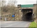
Railway bridge, Eldon Lane
Carries the Darlington to Bishop Auckland Railway.
Image: © JThomas
Taken: 13 Dec 2015
0.07 miles
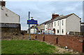
3
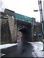
Bridge at Bridge Place
Bridge Place must be a remarkably small location.
Through the arch of the bridge and past a few houses there's another road sign naming the place but on the other side of the road, so at most, Bridge Place comprises the railway bridge and those few houses.
The sign naming Bridge Place is of course in the blue and yellow style commonly found to name places in County Durham; there does seem to be an unusual density of such signs in the area around Bishop Auckland.
Image: © Trevor Littlewood
Taken: 24 Mar 2016
0.09 miles
4
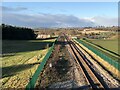
Darlington - Bishop Auckland Railway
View of the railway shortly after exiting Shildon tunnel at Eldon.
Image: © David Robinson
Taken: 30 Nov 2020
0.09 miles
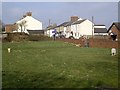
5
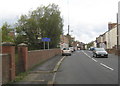
Terraced housing at Eldon Lane
Eldon Lane, rather than being a road, is a small settlement near to the larger ones of Bishop Auckland and Shildon; the blue and yellow road sign is in a style introduced in County Durham some time ago. The view is from the sadly neglected cemetery surrounding the Church of St. Mark.
Image: © Trevor Littlewood
Taken: 18 Feb 2014
0.12 miles
6
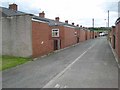
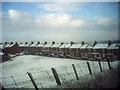
Back of Kimberley Street, Coundon Grange
A row of old miners bungalows.
Image: © Oliver Dixon
Taken: 5 Jul 2007
0.14 miles
7
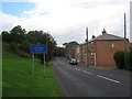
Entry to Eldon Lane
The High Street seen from the churchyard.
Image: © Stanley Howe
Taken: 13 Apr 2013
0.15 miles
8
Coronation, Eldon Lane.
Taken from the Bishop Auckland to Shildon Railway line
Image: © Neil Atterby
Taken: 5 Mar 2001
0.15 miles
9
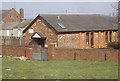
'Busy Base', Main Street, Eldon
A Sure Start Children's Centre for local families use; across the road from St Mark's church.
Image: © Stanley Howe
Taken: 13 Apr 2013
0.16 miles