IMAGES TAKEN NEAR TO
Westerton View, BISHOP AUCKLAND, DL14 8QS
Introduction
This page details the photographs taken nearby to Westerton View, DL14 8QS by members of the Geograph project.
The Geograph project started in 2005 with the aim of publishing, organising and preserving representative images for every square kilometre of Great Britain, Ireland and the Isle of Man.

There are currently over 7.5m images from over14,400 individuals and you can help contribute to the project by visiting https://www.geograph.org.uk
Image Map
Images are licensed for reuse under creativecommons.org/licenses/by-sa/2.0
Notes
- Clicking on the map will re-center to the selected point.
- The higher the marker number, the further away the image location is from the centre of the postcode.
Image Listing (18 Images Found)
Images are licensed for reuse under creativecommons.org/licenses/by-sa/2.0
Image
Details
Distance
2
Wharton Street, Coundon
Children's playground on the right.
Image: © Stanley Howe
Taken: 21 Sep 2013
0.10 miles
3
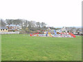
Playground in Wharton Street Coundon
Image: © Peter Robinson
Taken: 13 Mar 2011
0.11 miles
4
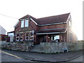
Coundon Conservative Club
On Collingwood Street.
Image: © JThomas
Taken: 6 Dec 2015
0.13 miles
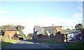
5
West End Villas Coundon County Durham
Image: © Peter Robinson
Taken: 30 Sep 2010
0.14 miles
6
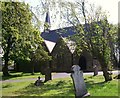
St James C Of E Church, Collingwood Street, Coundon, Bishop Auckland, Durham
Image: © Colin Summerson
Taken: 18 May 2010
0.15 miles
7
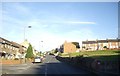
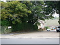
Entering Coundon from New Coundon
At junction with Church Street (B6287).
Image: © Stanley Howe
Taken: 21 Sep 2013
0.17 miles
9
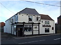
The Durham Ox, Coundon
On Collingwood Street.
Image: © JThomas
Taken: 6 Dec 2015
0.19 miles
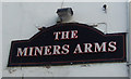
10
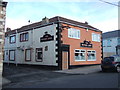
The Miners Arms, Coundon
On Collingwood Street.
Image: © JThomas
Taken: 6 Dec 2015
0.19 miles