IMAGES TAKEN NEAR TO
Russell Street, BISHOP AUCKLAND, DL14 7PT
Introduction
This page details the photographs taken nearby to Russell Street, DL14 7PT by members of the Geograph project.
The Geograph project started in 2005 with the aim of publishing, organising and preserving representative images for every square kilometre of Great Britain, Ireland and the Isle of Man.

There are currently over 7.5m images from over14,400 individuals and you can help contribute to the project by visiting https://www.geograph.org.uk
Image Map
Images are licensed for reuse under creativecommons.org/licenses/by-sa/2.0
Notes
- Clicking on the map will re-center to the selected point.
- The higher the marker number, the further away the image location is from the centre of the postcode.
Image Listing (56 Images Found)
Images are licensed for reuse under creativecommons.org/licenses/by-sa/2.0
Image
Details
Distance
1
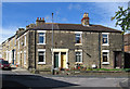
Bishop Auckland - houses at junction of Russell Street and West Road
Image: © Dave Bevis
Taken: 21 Sep 2013
0.01 miles
2
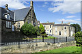
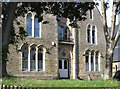
Building of Wesleyan Schools, Bishop Auckland
The Wesleyan Schools building, inscribed with its name and the date (probably 1858) is on the south side of Russell Street. The view is across Etherley Lane from the west end of Edward Street.
Image: © Trevor Littlewood
Taken: 16 Sep 2021
0.01 miles
3
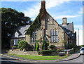
Bishop Auckland - former school at junction of Russell Street and West Road
Image: © Dave Bevis
Taken: 21 Sep 2013
0.02 miles
4
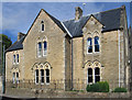
Bishop Auckland - St Wilfrid's RC Presbytery - from south
Image: © Dave Bevis
Taken: 21 Sep 2013
0.02 miles
5
Bishop Auckland - St Wilfrid's RC Presbytery - from east
Image: © Dave Bevis
Taken: 21 Sep 2013
0.03 miles
6
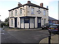
The Newton Cap : Town Head, Bishop Auckland
On Newton Cap Bank and Bridge Street
Image: © Hugh Mortimer
Taken: 21 Jan 2007
0.08 miles
7
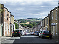
Surtees Street
Surtees Street, Bishop Auckland looking downhill from near the junction with Etherley Lane.
Image: © Trevor Littlewood
Taken: 16 Sep 2021
0.09 miles
8
Footbridge over the A689
Looking across a footbridge at the end of Gibbon Street connecting to Tenters Street.
Image: © DS Pugh
Taken: 9 Sep 2023
0.11 miles
9
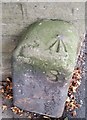
Boundary Stone with OS Rivet
This OS cut mark found on the Boundary Stone on Princess Street marks a point 110.185m above mean sea level.
Image: © Adrian Dust
Taken: 18 Sep 2018
0.11 miles
10
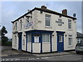
The Newton Cap, Bridge Street
Former pub now a children's nursery.
Image: © Alex McGregor
Taken: 8 Sep 2010
0.12 miles