IMAGES TAKEN NEAR TO
Grey Street, BISHOP AUCKLAND, DL14 7BQ
Introduction
This page details the photographs taken nearby to Grey Street, DL14 7BQ by members of the Geograph project.
The Geograph project started in 2005 with the aim of publishing, organising and preserving representative images for every square kilometre of Great Britain, Ireland and the Isle of Man.

There are currently over 7.5m images from over14,400 individuals and you can help contribute to the project by visiting https://www.geograph.org.uk
Image Map
Images are licensed for reuse under creativecommons.org/licenses/by-sa/2.0
Notes
- Clicking on the map will re-center to the selected point.
- The higher the marker number, the further away the image location is from the centre of the postcode.
Image Listing (93 Images Found)
Images are licensed for reuse under creativecommons.org/licenses/by-sa/2.0
Image
Details
Distance
1
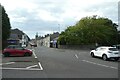
Prince's Street meets Gibbon Street
Looking across the junction of Prince's Street with Gibbon Street to the west of the town centre in Bishop Auckland.
Image: © DS Pugh
Taken: 9 Sep 2023
0.04 miles
2
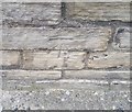
Ordnance Survey Cut Mark
This OS cut mark can be found on the south face of St Peter's Church. It marks a point 99.468m above mean sea level.
Image: © Adrian Dust
Taken: 18 Sep 2018
0.05 miles
3
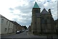
Bishop Auckland - St Peter's Church
On Princes Street. For an alternative view, please see Image
Image: © Dave Bevis
Taken: 21 Sep 2013
0.05 miles
4
Gibbon Street at the junction with Prince's Street
Looking towards the junction with Vickers Street ahead.
Image: © DS Pugh
Taken: 9 Sep 2023
0.05 miles
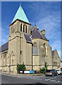
5
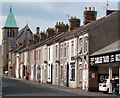
Princes Street, Bishop Auckland
Princes Street is in north-western Bishop Auckland. The church beyond the terrace is St. Peter's, described in the Pevsner guide for County Durham as having a copper 'fleche' which clearly refers to the covering of the spire.
Image: © Trevor Littlewood
Taken: 27 Sep 2011
0.05 miles
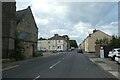
6
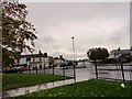
Roundabout on Princes Street, Bishop Auckland
Looking west on a wet autumn morning. The A689 is to the right. The tower of St Peter's Church is visible in the distance.
Image: © Robert Graham
Taken: 23 Oct 2013
0.07 miles
7
Bob Hardisty Drive
Looking across Bob Hardisty Drive onto the A689 at a roundabout.
Image: © DS Pugh
Taken: 9 Sep 2023
0.08 miles
8
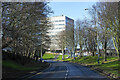
Bob Hardisty Drive
This road in Bishop Auckland is named for John Roderick Elliot "Bob" Hardisty who was born in Chester-Le-Street. He played football mainly for Bishop Auckland and also represented Great Britain at a number of Olympic Games.
Image: © Trevor Littlewood
Taken: 7 Feb 2022
0.11 miles
9
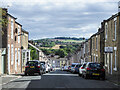
Surtees Street
Surtees Street, Bishop Auckland looking downhill from near the junction with Etherley Lane.
Image: © Trevor Littlewood
Taken: 16 Sep 2021
0.11 miles
10
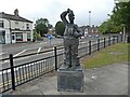
Stan Laurel statue, Bishop Auckland
A former resident, in his youth.
Image: © Roger Cornfoot
Taken: 24 Sep 2021
0.12 miles