IMAGES TAKEN NEAR TO
Irvin Avenue, BISHOP AUCKLAND, DL14 6QG
Introduction
This page details the photographs taken nearby to Irvin Avenue, DL14 6QG by members of the Geograph project.
The Geograph project started in 2005 with the aim of publishing, organising and preserving representative images for every square kilometre of Great Britain, Ireland and the Isle of Man.

There are currently over 7.5m images from over14,400 individuals and you can help contribute to the project by visiting https://www.geograph.org.uk
Image Map
Images are licensed for reuse under creativecommons.org/licenses/by-sa/2.0
Notes
- Clicking on the map will re-center to the selected point.
- The higher the marker number, the further away the image location is from the centre of the postcode.
Image Listing (6 Images Found)
Images are licensed for reuse under creativecommons.org/licenses/by-sa/2.0
Image
Details
Distance
1
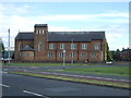
St Mary's Roman Catholic Church, Bishop Auckland
Image: © JThomas
Taken: 18 Jun 2018
0.16 miles
2
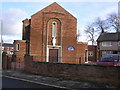
St. Mary's Catholic Church : Woodhouse Lane : Bishop Auckland
Image: © Hugh Mortimer
Taken: 21 Jan 2007
0.16 miles
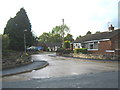
4
Woodhouse Church and Community Centre Proudfoot Drive Bishop Auckland
Image: © Peter Robinson
Taken: 30 Sep 2010
0.21 miles
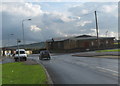
5
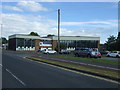
Woodhouse Close Leisure Complex, Bishop Auckland
Image: © JThomas
Taken: 18 Jun 2018
0.22 miles
6
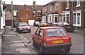
Percy Street Cockton Hill
No 3 (House with blue window frames) was the only one to retain the original Gas Lighting installation until the 1950s because the tenant refused to have electricity in the house. Said it was too dangerous
PS: The tenant was my Grandfather
Image: © Ken Crosby
Taken: 19 Jun 1998
0.23 miles