IMAGES TAKEN NEAR TO
Elm Terrace, BISHOP AUCKLAND, DL14 6EZ
Introduction
This page details the photographs taken nearby to Elm Terrace, DL14 6EZ by members of the Geograph project.
The Geograph project started in 2005 with the aim of publishing, organising and preserving representative images for every square kilometre of Great Britain, Ireland and the Isle of Man.

There are currently over 7.5m images from over14,400 individuals and you can help contribute to the project by visiting https://www.geograph.org.uk
Image Map
Images are licensed for reuse under creativecommons.org/licenses/by-sa/2.0
Notes
- Clicking on the map will re-center to the selected point.
- The higher the marker number, the further away the image location is from the centre of the postcode.
Image Listing (82 Images Found)
Images are licensed for reuse under creativecommons.org/licenses/by-sa/2.0
Image
Details
Distance
1
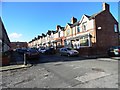
Oak Terrace, Bishop Auckland
Terraced street on the eastern side of the town. Possibly Edwardian in date.
Image: © Robert Graham
Taken: 23 Oct 2013
0.04 miles
2
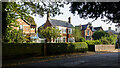
Detached houses on Cradock Street
Attractive properties on the north side of Cradock Street in Bishop Auckland which lies to the south of the town centre.
Image: © Trevor Littlewood
Taken: 16 Oct 2023
0.05 miles
3
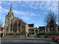
Bishop Auckland Methodist Church
Grade II listed. Listing number 1209024. Methodist Church with hall attached. 1903. By T E Davidson of Newcastle-upon-Tyne.
Image: © Andrew Abbott
Taken: 4 Jan 2020
0.08 miles
4
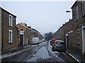
Cradock Street, Bishop Auckland
Looking east.
Image: © JThomas
Taken: 13 Dec 2015
0.08 miles
5
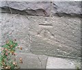
Ordnance Survey Cut Mark
This OS cut mark can be found on the west face of the Methodist Church. It marks a point 108.658m above mean sea level.
Image: © Adrian Dust
Taken: 18 Sep 2018
0.08 miles
6
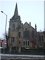
Bishop Auckland Methodist Church
On Cockton Hill Road.
Image: © JThomas
Taken: 13 Dec 2015
0.08 miles
7
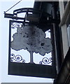
Sign for the Green Tree public house, Bishop Auckland
Image: © JThomas
Taken: 13 Dec 2015
0.10 miles
8
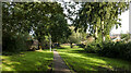
Linear park in Bishop Auckland
The park and walkway close to the centre of Bishop Auckland was once along the route of the South Durham and Lancashire Union Railway, better known as the Stainmore Line.
This particular stretch of the route between Bishop Auckland and Barnard Castle closed on 12 June 1962
Image: © Trevor Littlewood
Taken: 16 Oct 2023
0.10 miles
9
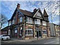
Green Tree public house
Grade II listed. Listing number 1196457. Public house. Dated 1900. Bright red brick with ashlar and faience dressings; pebble-dash rendered first floor and timber-framed gable. Roof plain red tiles, brick chimneys with ashlar dressings.
Image: © Andrew Abbott
Taken: 4 Jan 2020
0.10 miles
10
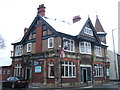
The Green Tree public house, Bishop Auckland
On Cockton Hill Road.
Image: © JThomas
Taken: 13 Dec 2015
0.10 miles