IMAGES TAKEN NEAR TO
South Church Road, BISHOP AUCKLAND, DL14 6DQ
Introduction
This page details the photographs taken nearby to South Church Road, DL14 6DQ by members of the Geograph project.
The Geograph project started in 2005 with the aim of publishing, organising and preserving representative images for every square kilometre of Great Britain, Ireland and the Isle of Man.

There are currently over 7.5m images from over14,400 individuals and you can help contribute to the project by visiting https://www.geograph.org.uk
Image Map
Images are licensed for reuse under creativecommons.org/licenses/by-sa/2.0
Notes
- Clicking on the map will re-center to the selected point.
- The higher the marker number, the further away the image location is from the centre of the postcode.
Image Listing (25 Images Found)
Images are licensed for reuse under creativecommons.org/licenses/by-sa/2.0
Image
Details
Distance
1

The Grand Hotel, Bishop Auckland
On South Church Road.
Image: © JThomas
Taken: 27 Aug 2018
0.01 miles
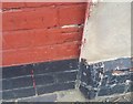
2
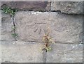
Ordnance Survey Cut Mark
This OS cut mark can be found on No1 St Andrews Crescent. It marks a point 98.682m above mean sea level.
Image: © Adrian Dust
Taken: 18 Sep 2018
0.03 miles
3
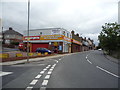
Autocare Centre, Bishop Auckland
On the South Church Road (A689).
Image: © JThomas
Taken: 27 Aug 2018
0.05 miles
4
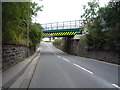
Railway bridge over South Church Road (A689), Bishop Auckland
Carries the Bishop Line between Darlington and Bishop Auckland.
Image: © JThomas
Taken: 27 Aug 2018
0.06 miles
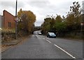
6
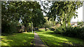
Linear park in Bishop Auckland
The park and walkway close to the centre of Bishop Auckland was once along the route of the South Durham and Lancashire Union Railway, better known as the Stainmore Line.
This particular stretch of the route between Bishop Auckland and Barnard Castle closed on 12 June 1962
Image: © Trevor Littlewood
Taken: 16 Oct 2023
0.07 miles
7
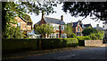
Detached houses on Cradock Street
Attractive properties on the north side of Cradock Street in Bishop Auckland which lies to the south of the town centre.
Image: © Trevor Littlewood
Taken: 16 Oct 2023
0.12 miles
8
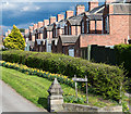
Houses on Salisbury Place
The rear of houses on the north side of Salisbury Place as seen from the Asda car park in Bishop Auckland. The road at the left side of the image leads, obviously, to the cemetery.
Image: © Trevor Littlewood
Taken: 10 Apr 2017
0.14 miles
9
Ordnance Survey Cut Mark
This OS cut mark can be found on No2 Woodlands Road. It marks a point 97.661m above mean sea level.
Image: © Adrian Dust
Taken: 18 Sep 2018
0.16 miles
10
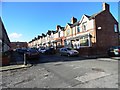
Oak Terrace, Bishop Auckland
Terraced street on the eastern side of the town. Possibly Edwardian in date.
Image: © Robert Graham
Taken: 23 Oct 2013
0.17 miles