IMAGES TAKEN NEAR TO
Brewer Street, BISHOP AUCKLAND, DL14 6AT
Introduction
This page details the photographs taken nearby to Brewer Street, DL14 6AT by members of the Geograph project.
The Geograph project started in 2005 with the aim of publishing, organising and preserving representative images for every square kilometre of Great Britain, Ireland and the Isle of Man.

There are currently over 7.5m images from over14,400 individuals and you can help contribute to the project by visiting https://www.geograph.org.uk
Image Map
Images are licensed for reuse under creativecommons.org/licenses/by-sa/2.0
Notes
- Clicking on the map will re-center to the selected point.
- The higher the marker number, the further away the image location is from the centre of the postcode.
Image Listing (28 Images Found)
Images are licensed for reuse under creativecommons.org/licenses/by-sa/2.0
Image
Details
Distance
1
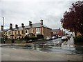
Junction of Northumberland Avenue with Cockton Hill Road, Bishop Auckland
On the southern side of the town. A nice old stone terrace here, probably late Victorian or Edwardian. It's noticeable that the terraces behind are brick, not stone, so possibly lower class than the front terrace.
Image: © Robert Graham
Taken: 23 Oct 2013
0.02 miles
2
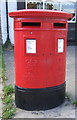
Double Elizabeth II postbox on Cockton Hill Road, Bishop Auckland
Postbox No. DL14 10.
Image: © JThomas
Taken: 18 Jun 2018
0.03 miles
3
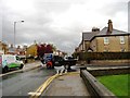
Coal wagon on Cockton Hill Road, Bishop Auckland
Not a common sight these days.
Image: © Robert Graham
Taken: 23 Oct 2013
0.04 miles
4
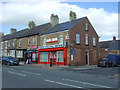
Cockton Hill News and Post Office, Bishop Auckland
On Cockton Hill Road.
Image: © JThomas
Taken: 18 Jun 2018
0.05 miles
5
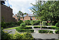
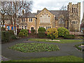
Tittybottle Park, Bishop Auckland
The delightfully named 'Tittybottle Park' which was restored in 2011. The origin of the name - a nickname really - is reportedly that nursemaids would gather there in earlier times when this was an affluent part of the town to chat and feed their babies. The view is from the entrance gate.
It seems that there are other parks known by the same name, either officially or colloquially - here's one from Otley - https://www.geograph.org.uk/photo/1937873 .
Image: © Trevor Littlewood
Taken: 13 Aug 2021
0.10 miles
6
Park and church in Bishop Auckland
The Bishop Auckland Baptist Church is seen across the delightfully named Tittybottle Park which has been restored recently: 2011. The origin of the name - a nickname really - is reportedly that nursemaids would gather there in earlier times (when this was an affluent part of the town) to chat and feed their babies.
Image: © Trevor Littlewood
Taken: 25 Jan 2012
0.11 miles
7
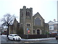
Bishop Auckland Baptist Church
On Cockton Hill Road.
Image: © JThomas
Taken: 13 Dec 2015
0.12 miles
8
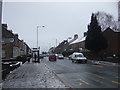
Bus stop and shelter on Cockton Hill Road
Looking south.
Image: © JThomas
Taken: 13 Dec 2015
0.12 miles
9
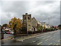
Bishop Auckland Baptist Church
On Cockton Hill Road, on the way south from the town centre. Bishop Auckland Hospital can be seen beyond the church.
Image: © Robert Graham
Taken: 23 Oct 2013
0.12 miles
10
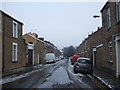
Cradock Street, Bishop Auckland
Looking east.
Image: © JThomas
Taken: 13 Dec 2015
0.14 miles