IMAGES TAKEN NEAR TO
Ramshaw, BISHOP AUCKLAND, DL14 0PE
Introduction
This page details the photographs taken nearby to DL14 0PE by members of the Geograph project.
The Geograph project started in 2005 with the aim of publishing, organising and preserving representative images for every square kilometre of Great Britain, Ireland and the Isle of Man.

There are currently over 7.5m images from over14,400 individuals and you can help contribute to the project by visiting https://www.geograph.org.uk
Image Map
Images are licensed for reuse under creativecommons.org/licenses/by-sa/2.0
Notes
- Clicking on the map will re-center to the selected point.
- The higher the marker number, the further away the image location is from the centre of the postcode.
Image Listing (8 Images Found)
Images are licensed for reuse under creativecommons.org/licenses/by-sa/2.0
Image
Details
Distance
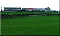
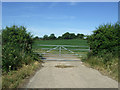
3
Farm at High Toft Hill
The farm as seen from the road to the south. Little Moor Farm is also in view; its buildings are to the right.
Image: © Trevor Littlewood
Taken: 9 May 2012
0.10 miles
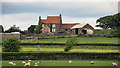
5
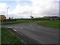
Crossroads (B 6282)
Looking West, Toft Hill Lane to the right.
Image: © Hugh Mortimer
Taken: 21 Oct 2006
0.18 miles
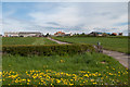
6
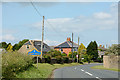
B6282 entering Toft Hill
A major road, the A68, passes through the length of Toft Hill - it lies ahead along this lesser road, the B6282 which approaches the village from the south-west.
The blue and yellow road sign is in the colours and style introduced in County Durham some years ago.
Image: © Trevor Littlewood
Taken: 4 Jul 2013
0.19 miles
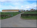
8
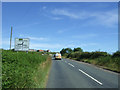
Minor road towards Toft Hill
Looking north, Bowes Hill.
Image: © JThomas
Taken: 25 Jun 2018
0.22 miles