IMAGES TAKEN NEAR TO
Ramshaw, BISHOP AUCKLAND, DL14 0NT
Introduction
This page details the photographs taken nearby to DL14 0NT by members of the Geograph project.
The Geograph project started in 2005 with the aim of publishing, organising and preserving representative images for every square kilometre of Great Britain, Ireland and the Isle of Man.

There are currently over 7.5m images from over14,400 individuals and you can help contribute to the project by visiting https://www.geograph.org.uk
Image Map
Images are licensed for reuse under creativecommons.org/licenses/by-sa/2.0
Notes
- Clicking on the map will re-center to the selected point.
- The higher the marker number, the further away the image location is from the centre of the postcode.
Image Listing (27 Images Found)
Images are licensed for reuse under creativecommons.org/licenses/by-sa/2.0
Image
Details
Distance
1
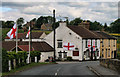
The Bridge Inn
The Bridge Inn at Ramshaw.
Image: © Peter McDermott
Taken: 12 Jun 2010
0.08 miles
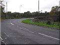
2
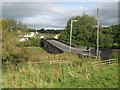
Evenwood Bridge, County Durham
Seen from the southern side the bridge spans the River Gaunless
Image: © Peter Robinson
Taken: 27 Sep 2009
0.09 miles
3
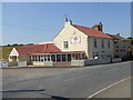
Big Joe's
Steakhouse and bar. The Bridge Inn has been the subject of a makeover some time in the last eight years - see Image
Image: © Oliver Dixon
Taken: 29 Jun 2018
0.09 miles
4
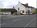
The Bridge Inn : Ramshaw
On the western side of Ramshaw Bridge
Image: © Hugh Mortimer
Taken: 21 Oct 2006
0.09 miles
5
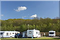
Craggwood Caravan Park
Gordon Lane, Ramshaw.
Image: © Jo and Steve Turner
Taken: 26 May 2013
0.09 miles
6
Ramshaw Bridge : Oak Bank : Ramshaw
Traffic light controlled bridge over the River Gaunless and a disused colliery railway line.
Image: © Hugh Mortimer
Taken: 21 Oct 2006
0.11 miles
7
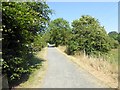
Railway path at Ramshaw
A railway path runs from Ramshaw to Spring Gardens. After about 600 metres, the path switches to the course of another slightly higher railway.
Image: © Oliver Dixon
Taken: 29 Jun 2018
0.11 miles
9
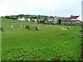
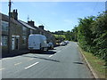
Ramshaw
South western aspect of the former colliery village of Ramshaw. The colliery operated between 1942 and 1959.
Image: © Mick Garratt
Taken: 2 Oct 2005
0.12 miles
10
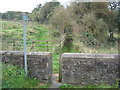
Two footpath stiles Evenwood
On the southern side of Evenwood Bridge providing stock retention and giving access along a public footpath to the north west of the town in County Durham
Image: © Peter Robinson
Taken: 27 Sep 2009
0.12 miles