IMAGES TAKEN NEAR TO
Leazes Lane, BISHOP AUCKLAND, DL14 0HR
Introduction
This page details the photographs taken nearby to Leazes Lane, DL14 0HR by members of the Geograph project.
The Geograph project started in 2005 with the aim of publishing, organising and preserving representative images for every square kilometre of Great Britain, Ireland and the Isle of Man.

There are currently over 7.5m images from over14,400 individuals and you can help contribute to the project by visiting https://www.geograph.org.uk
Image Map
Images are licensed for reuse under creativecommons.org/licenses/by-sa/2.0
Notes
- Clicking on the map will re-center to the selected point.
- The higher the marker number, the further away the image location is from the centre of the postcode.
Image Listing (4 Images Found)
Images are licensed for reuse under creativecommons.org/licenses/by-sa/2.0
Image
Details
Distance
1
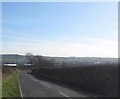
Leazes Lane leading down to St Helen Auckland
Image: © Peter Robinson
Taken: 2 Mar 2011
0.07 miles
2
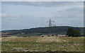
Stubble field with pylon
The field lies on the south side of Greenfields Road near to West Auckland. Brusselton Wood is on the skyline, beyond the valley of the River Gaunless.
Image: © Trevor Littlewood
Taken: 27 Aug 2014
0.21 miles
3
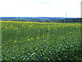
Field of oilseed rape off Greenfields Road
An early crop - oilseed rape is in flower before the leaves are on the trees. Evenwood village Image can be seen on the far side of the Gaunless valley.
Image: © Oliver Dixon
Taken: 11 Apr 2014
0.24 miles
4
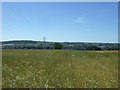
Grassland and power lines near Woodhouse Farm
Off Greenfields Road.
Image: © JThomas
Taken: 25 Jun 2018
0.24 miles