IMAGES TAKEN NEAR TO
Royal Court, BISHOP AUCKLAND, DL14 0ET
Introduction
This page details the photographs taken nearby to Royal Court, DL14 0ET by members of the Geograph project.
The Geograph project started in 2005 with the aim of publishing, organising and preserving representative images for every square kilometre of Great Britain, Ireland and the Isle of Man.

There are currently over 7.5m images from over14,400 individuals and you can help contribute to the project by visiting https://www.geograph.org.uk
Image Map
Images are licensed for reuse under creativecommons.org/licenses/by-sa/2.0
Notes
- Clicking on the map will re-center to the selected point.
- The higher the marker number, the further away the image location is from the centre of the postcode.
Image Listing (8 Images Found)
Images are licensed for reuse under creativecommons.org/licenses/by-sa/2.0
Image
Details
Distance
2
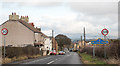
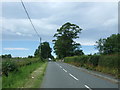
Sloshes Lane entering Witton Park
Witton Park is a small County Durham village. The blue and yellow road sign is in a style in use in the county for many years.
Image: © Trevor Littlewood
Taken: 10 Feb 2018
0.05 miles
3
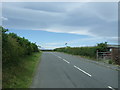
The Baltic
Looking west on National Cycle Route 70.
Image: © JThomas
Taken: 18 Jun 2018
0.06 miles
4
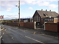
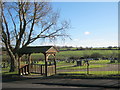
St.Chad's Elementary School : Witton Park
Image: © Hugh Mortimer
Taken: 26 Nov 2006
0.15 miles
8
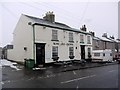
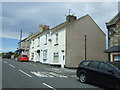
Rose & Crown, Witton Park
A web search for this establishment shows that it hosts an exceptional Sunday League football team with successes going back to the early 1900s. Some of their story is here http://www.thenorthernecho.co.uk/sport/columnists/backtrack/4034258.A_visit_to_Canada_for_Rose_and_Crown/
Image: © Andrew Curtis
Taken: 21 Feb 2010
0.25 miles