IMAGES TAKEN NEAR TO
St. James Gardens, BISHOP AUCKLAND, DL14 0BG
Introduction
This page details the photographs taken nearby to St. James Gardens, DL14 0BG by members of the Geograph project.
The Geograph project started in 2005 with the aim of publishing, organising and preserving representative images for every square kilometre of Great Britain, Ireland and the Isle of Man.

There are currently over 7.5m images from over14,400 individuals and you can help contribute to the project by visiting https://www.geograph.org.uk
Image Map
Images are licensed for reuse under creativecommons.org/licenses/by-sa/2.0
Notes
- Clicking on the map will re-center to the selected point.
- The higher the marker number, the further away the image location is from the centre of the postcode.
Image Listing (34 Images Found)
Images are licensed for reuse under creativecommons.org/licenses/by-sa/2.0
Image
Details
Distance
1
Cemetery Road, Witton-le-Wear
Looking north west.
Image: © JThomas
Taken: 18 Jun 2018
0.05 miles
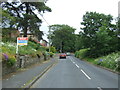
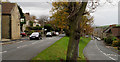
2
Cemetery Road entering Witton-le-Wear
The road, appropriately, is seen as it passes the village cemetery. The blue and yellow road sign is in the style of many such in County Durham.
Image: © Trevor Littlewood
Taken: 19 Feb 2016
0.05 miles
3
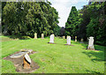
Cemetery at Witton-le-Wear
For a small village, Witton-le-Wear has a surprisingly large cemetery; it extends into and beyond the trees at the left side of the image. There are graves at the Church of St Philip and St James in the village centre but space there is limited and presumably all burials now take place at this location, just to the north.
Image: © Trevor Littlewood
Taken: 30 Jul 2019
0.08 miles
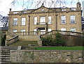
5
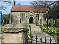
Church Witton-le-Wear
Steps and entrance to St Philip and St James Church in this County Durham village.
Image: © Peter Robinson
Taken: 5 Apr 2009
0.12 miles
6
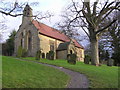
St. Philip and St. James Church : Witton-le-Wear
The church is of early 12c origin, with extensive rebuilding over the years, the south door, dated 1664.
Image: © Hugh Mortimer
Taken: 5 Jan 2007
0.13 miles
7
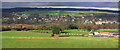
Witton-le-Wear
Taken looking north from Sloshes Lane, with West Witton Row Farm (foreground right). The A68 crosses the River Wear to the left.
Image: © Hugh Mortimer
Taken: 26 Nov 2006
0.14 miles
8
A Corner of Witton-le-Wear
Cemetery Road heading out of the village towards Howden-le-Wear
Image: © Chris Heaton
Taken: 20 May 2022
0.15 miles
9
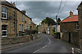
Witton-le-Wear
Witton-le-Wear is a small, attractive village north of the River Wear; the view is of the village centre, looking east.
Image: © Trevor Littlewood
Taken: 5 Nov 2010
0.15 miles
10

Witton-le-Wear
Much of the village is tidily arranged around a long thin green
Image: © Chris Heaton
Taken: 20 May 2022
0.15 miles