IMAGES TAKEN NEAR TO
Witton Le Wear, BISHOP AUCKLAND, DL14 0AJ
Introduction
This page details the photographs taken nearby to DL14 0AJ by members of the Geograph project.
The Geograph project started in 2005 with the aim of publishing, organising and preserving representative images for every square kilometre of Great Britain, Ireland and the Isle of Man.

There are currently over 7.5m images from over14,400 individuals and you can help contribute to the project by visiting https://www.geograph.org.uk
Image Map
Images are licensed for reuse under creativecommons.org/licenses/by-sa/2.0
Notes
- Clicking on the map will re-center to the selected point.
- The higher the marker number, the further away the image location is from the centre of the postcode.
Image Listing (34 Images Found)
Images are licensed for reuse under creativecommons.org/licenses/by-sa/2.0
Image
Details
Distance
1
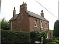
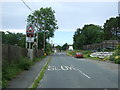
Station House
Now a private residence, formerly adjacent to the Bishop Auckland to Eastgate railway route in Weardale County Durham
Image: © Peter Robinson
Taken: 6 Sep 2009
0.02 miles
2
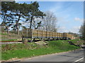
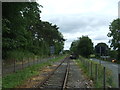
Train halt at Witton-le-Wear for the Weardale Railway
Image: © Peter Robinson
Taken: 2 May 2013
0.02 miles
3

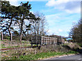
Bridge over unnamed watercourse for multi user route alongside the Weardale Railway
Image: © Peter Robinson
Taken: 22 Apr 2012
0.06 miles
4
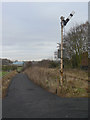
Signal at Witton-le-Wear
The railway is currently disused except to provide access to the Weardale Railway, but work is under way to reopen the line from Wolsingham to Shildon.
Image: © Alan Murray-Rust
Taken: 10 Nov 2009
0.06 miles
5
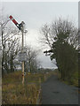
Signal at Witton-le-Wear
The railway is currently disused except to provide access to the Weardale Railway, but work is under way to reopen the line from Wolsingham to Shildon. The footpath to the right is on the site of the old station.
Image: © Alan Murray-Rust
Taken: 10 Nov 2009
0.06 miles
6
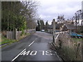
Approaching level crossing on Low Lane, Witton-le-Wear
Image: © JThomas
Taken: 18 Jun 2018
0.07 miles
7
Station for the Weardale Railway, Witton-le-Wear
View from the level crossing.
Image: © JThomas
Taken: 18 Jun 2018
0.08 miles
8
Railway platform at Witton-le-Wear
The Weardale railway originally ran from Bishop Auckland to Eastgate. Passenger services ceased in 1953, and freight in 1993. At that point, a trust was formed to preserve and run the line privately. As a heritage railway, the project has suffered some ups and downs in fortune, but is now running during the summer between Bishop Auckland West and Stanhope. This platform at Witton-le-Wear has been constructed in anticipation of a station being opened at this location.
Image: © Oliver Dixon
Taken: 11 Apr 2014
0.09 miles
9

Level crossing for footpath over the Weardale Railway east of Witton-le-Wear
Image: © Peter Robinson
Taken: 22 Apr 2012
0.10 miles
10
Level Crossing : Station Road : Witton-le-Wear
Crossing the disused Stockton & Darlington Railway (1847), Station Road. The original station visible (centre). In 1852 a new station (now demolished) was built to the east (Frosterley & Stanhope Railway). In the 1930's was the home of the LNER District Engineer, and closed to passengers in June 1953, goods traffic continued until November 1965.
Image: © Hugh Mortimer
Taken: 5 Jan 2007
0.11 miles