IMAGES TAKEN NEAR TO
Stirling Grove, DARLINGTON, DL1 3TZ
Introduction
This page details the photographs taken nearby to Stirling Grove, DL1 3TZ by members of the Geograph project.
The Geograph project started in 2005 with the aim of publishing, organising and preserving representative images for every square kilometre of Great Britain, Ireland and the Isle of Man.

There are currently over 7.5m images from over14,400 individuals and you can help contribute to the project by visiting https://www.geograph.org.uk
Image Map
Images are licensed for reuse under creativecommons.org/licenses/by-sa/2.0
Notes
- Clicking on the map will re-center to the selected point.
- The higher the marker number, the further away the image location is from the centre of the postcode.
Image Listing (6 Images Found)
Images are licensed for reuse under creativecommons.org/licenses/by-sa/2.0
Image
Details
Distance
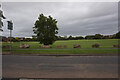
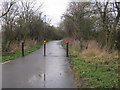
1
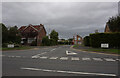
Oakwood Drive off Salters Lane North, Darlington
Image: © Ian S
Taken: 11 Sep 2020
0.10 miles
2
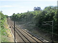
East coast mainline from Green Lane railway bridge
View of the east coast mainline from Green Lane railway bridge
Image: © Dylan Chester
Taken: 9 Jul 2022
0.18 miles
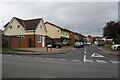
5
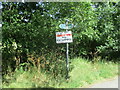
Signs on Green Lane
Two public bridleway signs and a no fly tipping sign on Green Lane
Image: © Dylan Chester
Taken: 9 Jul 2022
0.23 miles