IMAGES TAKEN NEAR TO
Sorrel Close, DARLINGTON, DL1 3FD
Introduction
This page details the photographs taken nearby to Sorrel Close, DL1 3FD by members of the Geograph project.
The Geograph project started in 2005 with the aim of publishing, organising and preserving representative images for every square kilometre of Great Britain, Ireland and the Isle of Man.

There are currently over 7.5m images from over14,400 individuals and you can help contribute to the project by visiting https://www.geograph.org.uk
Image Map
Images are licensed for reuse under creativecommons.org/licenses/by-sa/2.0
Notes
- Clicking on the map will re-center to the selected point.
- The higher the marker number, the further away the image location is from the centre of the postcode.
Image Listing (6 Images Found)
Images are licensed for reuse under creativecommons.org/licenses/by-sa/2.0
Image
Details
Distance
1
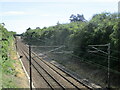
East coast mainline from Green Lane railway bridge
View of the east coast mainline from Green Lane railway bridge
Image: © Dylan Chester
Taken: 9 Jul 2022
0.10 miles
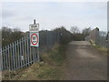
2
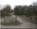
Bridleway entrance Glebe Road Darlington
At the northern end the road leading to open countryside known locally as 'Ketton Country' to the north east of Darlington
Image: © Peter Robinson
Taken: 27 Jan 2010
0.10 miles
4
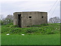
Pill box : WWII
Near Glebe Road Railway Bridge.
Image: © Hugh Mortimer
Taken: 30 Apr 2006
0.15 miles