IMAGES TAKEN NEAR TO
Woodland, BISHOP AUCKLAND, DL13 5RT
Introduction
This page details the photographs taken nearby to DL13 5RT by members of the Geograph project.
The Geograph project started in 2005 with the aim of publishing, organising and preserving representative images for every square kilometre of Great Britain, Ireland and the Isle of Man.

There are currently over 7.5m images from over14,400 individuals and you can help contribute to the project by visiting https://www.geograph.org.uk
Image Map
Images are licensed for reuse under creativecommons.org/licenses/by-sa/2.0
Notes
- Clicking on the map will re-center to the selected point.
- The higher the marker number, the further away the image location is from the centre of the postcode.
Image Listing (9 Images Found)
Images are licensed for reuse under creativecommons.org/licenses/by-sa/2.0
Image
Details
Distance
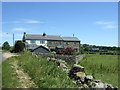
3

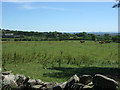
Drystone wall near Woodland
Drystone walls are built without mortar, and their stability – they can stand for 200 years – is due to the skill of the craftsmen who place rough boulders and angular stones together.
Many drystone walls were constructed as part of the enclosure of open grazing. They were especially useful in areas too exposed for hedgerows to survive and where stones were readily available.
Most drystone walls are wider at the base than at the crown, and are often capped with coping stones. A typical wall has two outer layers of large, flattish stones enclosing an inner ‘heart’ of smaller, rounder stones. Often it is reinforced with ‘through bands’ of even larger, flat stones which can also be used as stiles.
The very dryness of a wall makes it more likely to endure wind and frost and to act as shelter for livestock as well as a boundary.
Image: © Maigheach-gheal
Taken: 5 Apr 2011
0.14 miles
5
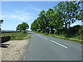
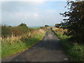
National Cycle Route 70
The B6282 towards Eggleston.
Image: © JThomas
Taken: 25 Jun 2018
0.17 miles
6
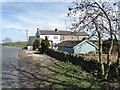
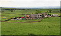
Houses at the B6282 junction near Woodlands
Image: © Oliver Dixon
Taken: 6 Apr 2011
0.19 miles
8
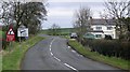
B6282 Junction : Woodland
The west end of Woodland, with Cust Barn Cottage on the right
Image: © Hugh Mortimer
Taken: 25 Feb 2007
0.20 miles