IMAGES TAKEN NEAR TO
Copley Bent, BISHOP AUCKLAND, DL13 5QN
Introduction
This page details the photographs taken nearby to Copley Bent, DL13 5QN by members of the Geograph project.
The Geograph project started in 2005 with the aim of publishing, organising and preserving representative images for every square kilometre of Great Britain, Ireland and the Isle of Man.

There are currently over 7.5m images from over14,400 individuals and you can help contribute to the project by visiting https://www.geograph.org.uk
Image Map
Images are licensed for reuse under creativecommons.org/licenses/by-sa/2.0
Notes
- Clicking on the map will re-center to the selected point.
- The higher the marker number, the further away the image location is from the centre of the postcode.
Image Listing (8 Images Found)
Images are licensed for reuse under creativecommons.org/licenses/by-sa/2.0
Image
Details
Distance
1
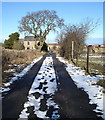
Track from West Garth to Copley Bent
A public footpath follows this track from the Copley road south towards two farms apparently both called West Garth, and beyond, to High West Garth overlooking the River Gaunless. This view looks back to houses on the north side of the B6282.
Image: © Andy Waddington
Taken: 11 Feb 2010
0.12 miles
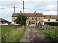
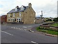
3
Entrance to Simpson Fuels Ltd., West Garth
Image: © Andrew Curtis
Taken: 21 Aug 2015
0.14 miles
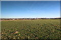
4
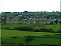
Copley Bent
Both Copley Bent (nearest ridge of houses) and Butterknowle (next ridge) had collieries. Butterknowle was the last to be abandoned in 1950.
Image: © Mick Garratt
Taken: 2 Oct 2005
0.15 miles
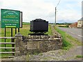
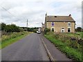
5
Junction of Copley Bent and Quarry Lane
Image: © Andrew Curtis
Taken: 21 Aug 2015
0.16 miles
7
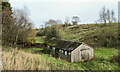
Shed close to Grewburn Beck
Grewburn Beck flows in a shallow valley to the south of Butterknowle.
Image: © Trevor Littlewood
Taken: 27 Nov 2022
0.25 miles
8
Field corner by Copley Lane
Taken from almost the only public footpath in the square, this view from the Copley Bent Farm access track looks to the corner of the field which it crosses, adjacent to Copley Lane. Beyond that lie the houses of Copley Bent itself.
Image: © Andy Waddington
Taken: 18 Dec 2021
0.25 miles