IMAGES TAKEN NEAR TO
Woodland, BISHOP AUCKLAND, DL13 5NG
Introduction
This page details the photographs taken nearby to DL13 5NG by members of the Geograph project.
The Geograph project started in 2005 with the aim of publishing, organising and preserving representative images for every square kilometre of Great Britain, Ireland and the Isle of Man.

There are currently over 7.5m images from over14,400 individuals and you can help contribute to the project by visiting https://www.geograph.org.uk
Image Map (Loading...)


Getting Data...Please wait
Leaflet Map data © OpenStreetMap
Images are licensed for reuse under creativecommons.org/licenses/by-sa/2.0
Notes
- Clicking on the map will re-center to the selected point.
- The higher the marker number, the further away the image location is from the centre of the postcode.
Image Listing (20 Images Found)
Images are licensed for reuse under creativecommons.org/licenses/by-sa/2.0
Image
Details
Distance
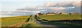
2

Entering Woodland
Looking south east on an unnamed road.
Image: © JThomas
Taken: 18 Jun 2018
0.18 miles
3
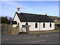
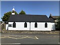
St. Mary's Church : Woodland
Corrugated iron church. Built 1906.
Image: © Hugh Mortimer
Taken: 4 Feb 2007
0.18 miles
4
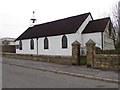
St Mary's Church, Woodland
It is very unusual to see a corrugated iron church in this part of the country.
Image: © Maigheach-gheal
Taken: 5 Apr 2011
0.18 miles
5
St. Mary's Church, Woodland
Corrugated iron church built 1906.
Image: © JThomas
Taken: 18 Jun 2018
0.18 miles
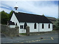
7
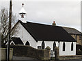
St Mary's Church, Woodland
An unusual sight in County Durham; a church in corrugated iron.
Image: © Trevor Littlewood
Taken: 15 Dec 2010
0.19 miles
8
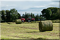
Silage baling near Woodland
The field is on the north side of the road through Woodland and is viewed from a minor road heading north-west from the village towards Hamsterley Forest.
Image: © Trevor Littlewood
Taken: 29 Aug 2015
0.20 miles
9
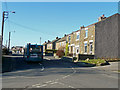
Bus service in Woodland
An ex-mining village on the edge of the Durham Moors.
Image: © Jonathan Billinger
Taken: 13 Feb 2008
0.20 miles
10
Blocked footpath at Woodland
Woodland Parish Footpath No 6 as shown on Durham County Council's online Definitive Map of Public Rights of Way. The gap in the drystone wall has been closed with stone and mortar. The Council's Public Rights of Way Officer for that area is now aware of this problem.
Image: © Peter Robinson
Taken: 1 Aug 2010
0.21 miles