IMAGES TAKEN NEAR TO
Station Houses, BISHOP AUCKLAND, DL13 5HH
Introduction
This page details the photographs taken nearby to Station Houses, DL13 5HH by members of the Geograph project.
The Geograph project started in 2005 with the aim of publishing, organising and preserving representative images for every square kilometre of Great Britain, Ireland and the Isle of Man.

There are currently over 7.5m images from over14,400 individuals and you can help contribute to the project by visiting https://www.geograph.org.uk
Image Map (Loading...)


Getting Data...Please wait
Leaflet Map data © OpenStreetMap
Images are licensed for reuse under creativecommons.org/licenses/by-sa/2.0
Notes
- Clicking on the map will re-center to the selected point.
- The higher the marker number, the further away the image location is from the centre of the postcode.
Image Listing (8 Images Found)
Images are licensed for reuse under creativecommons.org/licenses/by-sa/2.0
Image
Details
Distance
1
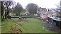
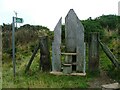
Cockfield Station : Bishop Auckland & Barnard Castle Railway
Opened in 1863, closed to passengers 1958. The Station House survives, track, bridge and sidings (to New Copley Coke Works) have gone. Part of the north-bound platform survives.
Image: © Hugh Mortimer
Taken: 24 Feb 2007
0.00 miles
2
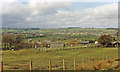
NW view over site of Cockfield Fell station in Gaunless valley to Woodland Fell and Hamsterley Forest
The station was just ahead, on the ex-North Eastern Railway Bishop Auckland (right) - Barnard Castle (left) line. The station was closed 15/9/58, the line on 18/6/62. See also Image
Image: © Ben Brooksbank
Taken: 30 Mar 1989
0.04 miles
3
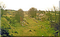
Remains of Cockfield Fell station
View SW, towards Barnard Castle: ex-North Eastern Bishop Auckland - Barnard Castle line. The station was closed 15/9/58, the line on 18/6/62.
Image: © Ben Brooksbank
Taken: 30 Mar 1989
0.04 miles
4
Course of Disused South Durham and Lancashire Railway
Built in 1862 this railway ran from Bishop Auckland to Barnard Castle. The old station of Haggerleases can be seen far right at the end of the curve. This is now a private residence.
Image: © Mick Garratt
Taken: 2 Oct 2005
0.05 miles
5
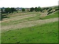
View north from Cockfield Fell
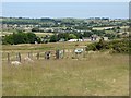
Cockfield Fell is a large public open space absolutely full of relics of the coal mining industry over many centuries. Butterknowle village can be seen on the far side of the Gaunless valley.
Image: © Oliver Dixon
Taken: 29 Jun 2018
0.09 miles
6
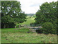
Cattle bridge
Spanning a gulley just west of Cockfield Fell County Durham
Image: © Peter Robinson
Taken: 2 Aug 2009
0.16 miles
8
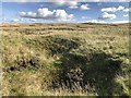
Cockfield Fell
Mounds and hollows on Cockfield Fell showing evidence of early coal mining activity.
The fell is the largest scheduled ancient monument in England, as well as early mining activity, the Fell contains iron age settlement enclosures, early waggonways and disused quarries.
Image: © David Robinson
Taken: 30 Sep 2019
0.25 miles