IMAGES TAKEN NEAR TO
Satley, BISHOP AUCKLAND, DL13 4HN
Introduction
This page details the photographs taken nearby to DL13 4HN by members of the Geograph project.
The Geograph project started in 2005 with the aim of publishing, organising and preserving representative images for every square kilometre of Great Britain, Ireland and the Isle of Man.

There are currently over 7.5m images from over14,400 individuals and you can help contribute to the project by visiting https://www.geograph.org.uk
Image Map (Loading...)


Getting Data...Please wait
Leaflet Map data © OpenStreetMap
Images are licensed for reuse under creativecommons.org/licenses/by-sa/2.0
Notes
- Clicking on the map will re-center to the selected point.
- The higher the marker number, the further away the image location is from the centre of the postcode.
Image Listing (3 Images Found)
Images are licensed for reuse under creativecommons.org/licenses/by-sa/2.0
Image
Details
Distance
1
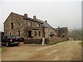
Farm buildings at West Shields
A large farmstead set in the countryside north of Tow Law, west of the B6296 road to Lanchester.
Image: © Robert Graham
Taken: 6 Mar 2013
0.21 miles
2
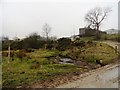
Approaching West Shields
The track to West Shields farm north of Tow Law runs across the Pan Burn. It gives the farm a very nice setting.
Image: © Robert Graham
Taken: 6 Mar 2013
0.23 miles
3
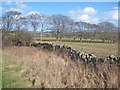
Row of trees
Seen from the B6296 Wolsingham to Lanchester road.
Image: © Oliver Dixon
Taken: 6 Mar 2007
0.24 miles