IMAGES TAKEN NEAR TO
Thornley Road, BISHOP AUCKLAND, DL13 4ED
Introduction
This page details the photographs taken nearby to Thornley Road, DL13 4ED by members of the Geograph project.
The Geograph project started in 2005 with the aim of publishing, organising and preserving representative images for every square kilometre of Great Britain, Ireland and the Isle of Man.

There are currently over 7.5m images from over14,400 individuals and you can help contribute to the project by visiting https://www.geograph.org.uk
Image Map (Loading...)


Getting Data...Please wait
Leaflet Map data © OpenStreetMap
Images are licensed for reuse under creativecommons.org/licenses/by-sa/2.0
Notes
- Clicking on the map will re-center to the selected point.
- The higher the marker number, the further away the image location is from the centre of the postcode.
Image Listing (51 Images Found)
Images are licensed for reuse under creativecommons.org/licenses/by-sa/2.0
Image
Details
Distance
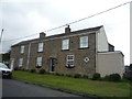
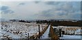
2
Houses in Tow Law, Thornley Road
This is the view of the rear of houses on Thornley Road in Tow Law. They are at the higher northern end of the road, close to its junction with Wolsingham Road.
Image: © Ian Porter
Taken: 11 Apr 2009
0.03 miles
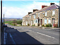
4
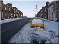
A view up Wolsingham Road
Passing snowploughs easily trap any vehicles on this hill, whether they are parked on the road or the wide pavement. To access Tow Law directly by car from the west there are only two ways in. This road is the better choice when the roads are dodgy, the other is Image The car belongs to a Head Chef of a local hotel, my ex boss :¬) Perhaps people are already starving due to global warming?
Compare with summer looking downhill Image
Image: © Ian Porter
Taken: 6 Feb 2009
0.04 miles
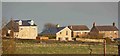
5
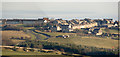
Tow Law
Tow Law from near castle Hills
Image: © Thomas Keetley
Taken: 3 Jan 2009
0.06 miles
6
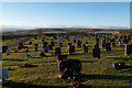
Cemetery at Tow Law
The cemetery lies to the south of Tow Law and on the west side of Thornley Road. The moors seen distantly are on the north side of the Wear valley above Stanhope and Wolsingham.
Image: © Trevor Littlewood
Taken: 8 Jan 2011
0.09 miles
7
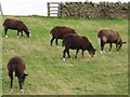
Zwartbles Sheep
"This breed was adopted by the Dutch Rare Breed Survival trust in the mid-1970s. Zwartbles are a docile and friendly sheep, and they are naturally polled (i.e. have no horns)."
Source: Zwartbles Sheep Association http://www.zwartbles.org/index.php?page=about-the-breed
Image: © Ian Porter
Taken: 21 Sep 2009
0.10 miles
8
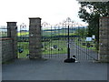
Entrance gates to Thornley road cemetery, Tow Law
The larger plaque on the gate has W.V.D.C. (Wear Valley District Council) on it. The District Council is no more, having been merged into the larger Durham County Council. As at the date of this photograph the cemetery is still in use.
Image: © Ian Porter
Taken: 9 Jul 2009
0.11 miles
9
View from Millennium Green, Tow Law
Millennium Green was recovered from waste land with grants from the Millennium Commission. The area has excellent views of Weardale and The North Pennines Area of Outstanding Natural Beauty.
Image: © Leanne Porter
Taken: 23 Feb 2010
0.12 miles
10
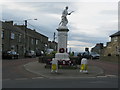
Tow Law War Memorial
Often referred to as 'The Memorial', the war memorial is a Grade II listed building. The most striking feature of the memorial is the sculpture of a First World War infantryman on the top.
Image: © G Laird
Taken: 3 Apr 2017
0.12 miles