IMAGES TAKEN NEAR TO
Dans Castle, BISHOP AUCKLAND, DL13 4AZ
Introduction
This page details the photographs taken nearby to Dans Castle, DL13 4AZ by members of the Geograph project.
The Geograph project started in 2005 with the aim of publishing, organising and preserving representative images for every square kilometre of Great Britain, Ireland and the Isle of Man.

There are currently over 7.5m images from over14,400 individuals and you can help contribute to the project by visiting https://www.geograph.org.uk
Image Map
Images are licensed for reuse under creativecommons.org/licenses/by-sa/2.0
Notes
- Clicking on the map will re-center to the selected point.
- The higher the marker number, the further away the image location is from the centre of the postcode.
Image Listing (47 Images Found)
Images are licensed for reuse under creativecommons.org/licenses/by-sa/2.0
Image
Details
Distance
1
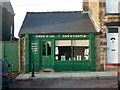
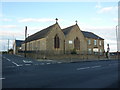
Anne's No126 Dan's Castle, Tow Law
Image: © Alexander P Kapp
Taken: 24 Aug 2011
0.01 miles
2
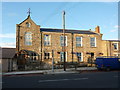
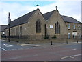
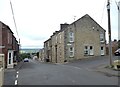
Former Wesleyan Chapel, Dan's Castle, Tow Law
Image: © Alexander P Kapp
Taken: 24 Aug 2011
0.02 miles
3
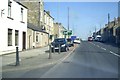
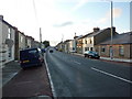
Dan's Castle (A68), Tow Law
Approach to B6301 junction for Lanchester.
Image: © Stanley Howe
Taken: 22 May 2012
0.02 miles
4
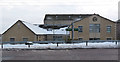
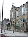
Tow Law Community Centre
Tow Law Community Centre is on the A68 at Castle Bank, Tow Law. The centre was considerably extended in 2004.
Image: © Ian Porter
Taken: 5 Feb 2009
0.05 miles
8
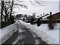
Valley Close, Tow Law
Valley Close is a cul-de-sac.
Image: © Ian Porter
Taken: 5 Feb 2009
0.08 miles
10
Ironworks Road, Tow Law
The ironworks in question only operated from 1845 to 1882.
Image: © Oliver Dixon
Taken: 17 Jul 2020
0.09 miles