IMAGES TAKEN NEAR TO
Deerness Estate, BISHOP AUCKLAND, DL13 4AR
Introduction
This page details the photographs taken nearby to Deerness Estate, DL13 4AR by members of the Geograph project.
The Geograph project started in 2005 with the aim of publishing, organising and preserving representative images for every square kilometre of Great Britain, Ireland and the Isle of Man.

There are currently over 7.5m images from over14,400 individuals and you can help contribute to the project by visiting https://www.geograph.org.uk
Image Map
Images are licensed for reuse under creativecommons.org/licenses/by-sa/2.0
Notes
- Clicking on the map will re-center to the selected point.
- The higher the marker number, the further away the image location is from the centre of the postcode.
Image Listing (51 Images Found)
Images are licensed for reuse under creativecommons.org/licenses/by-sa/2.0
Image
Details
Distance
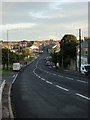
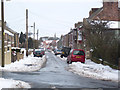
1
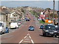
The A68 at Tow Law, County Durham
Hopefully this is more than just a road scene. The view is in a northerly direction on a lovely spring day. Contrast this with my other picture taken from the summit in this picture facing south. A gridline runs through this road and the picture was taken almost standing on a gridline.
Image]
Image: © Ian Porter
Taken: 13 Apr 2009
0.05 miles
4

Wind turbine nacelle passing through Tow Law on A68
I spotted this heavy load/wide vehicle coming towards me so I quickly got ahead of it and parked up. The vehicle had just cleared the main high street and was accelerating, hence the blurred picture taken at just 1/30 second and ISO 800.
The nacelle, the bit housing the turbine and that the blades are attached too was stunningly large, almost as high as the eaves of the houses. I would imagine that it's quite heavy too given that it is on a 5 axle/20 tyre flat bed trailer, complete with a German registration plate at the front.
I have submitted another pic showing a forward view, see Image]
For more info on the inside of the beast see http://www.windpower.org/en/kids/intro/intronac.htm
This is a wind turbine that will be noticeably taller than other wind turbines in the vicinity, 100 metres tip height, see the developers info at http://www.banksdevelopments.com/energy/sites/renewable/north_east/West_Durham_Wind_Farm/
Image: © Ian Porter
Taken: 6 Feb 2009
0.08 miles
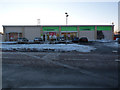
5
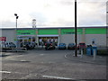
The new Co-operative store on the A68, Tow Law
The new Co-op opened in November 2008, it is on the west side of the A68 by the Newmarket public house. The site was formerly a petrol station but was closed about 2002. Planning permission was granted for the site in 2003 but not finally built on until 2008. Seen behind the building is the telecommunications mast of the Tow Law BT telephone exchange. At the right of the Co-op building is an ATM, the next nearest external ATM is in Crook*, just under 5 miles away. *Correct as at 2/12/08
Image: © Ian Porter
Taken: 2 Dec 2008
0.09 miles
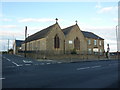
7
The Cattle Market, Tow Law
This approximately 125 year old building is all that remains of Tow Law's once thriving Auction Mart. It is a grade II listed building. The former auction site is now being developed for housing, some of which are clearly visible behind the "bull ring". The photograph was taken from a point where the former Cattle Mart pub stood. The future of the bull ring is uncertain, this has not been helped by vandalism to the building.
Image: © Ian Porter
Taken: 2 Dec 2008
0.09 miles
8
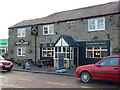
The Newmarket Pub, A68 High Street, Tow Law
A picture of the newly refurbished Newmarket public house. This was taken from the pavement on the other side of the A68. The new Co-op store can be seen to the left of the pub.
Image: © Ian Porter
Taken: 2 Dec 2008
0.09 miles
9
The new Co-op Tow Law
This is a picture of the New Co-op in Tow Law. If you compare it to my other picture Image] you can now see some damage to the right of the building. This was caused by a ram-raid on 23rd January 2009 using a JCB stolen from the building site across the road. See newspaper report at http://www.thenorthernecho.co.uk/news/4071265.Cash_point_ram_raided_with_JCB
Thankfully, the Co-op will be reinstating the ATM, new bollards can just be made out in the picture. The thieves did not get away with any money :)
Image: © Ian Porter
Taken: 6 Feb 2009
0.09 miles
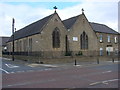
10
Grove Road, Tow Law
A short road in Tow Law. The Church spire in the centre is the Church of St. Philip and St. James's.
Image: © Ian Porter
Taken: 5 Feb 2009
0.09 miles