IMAGES TAKEN NEAR TO
Crane Row Lane, BISHOP AUCKLAND, DL13 3QU
Introduction
This page details the photographs taken nearby to Crane Row Lane, DL13 3QU by members of the Geograph project.
The Geograph project started in 2005 with the aim of publishing, organising and preserving representative images for every square kilometre of Great Britain, Ireland and the Isle of Man.

There are currently over 7.5m images from over14,400 individuals and you can help contribute to the project by visiting https://www.geograph.org.uk
Image Map
Images are licensed for reuse under creativecommons.org/licenses/by-sa/2.0
Notes
- Clicking on the map will re-center to the selected point.
- The higher the marker number, the further away the image location is from the centre of the postcode.
Image Listing (12 Images Found)
Images are licensed for reuse under creativecommons.org/licenses/by-sa/2.0
Image
Details
Distance
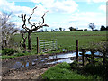
4
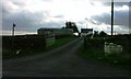
Recently cut silage field near New Field Farm
South of Crane Row Lane.
Image: © JThomas
Taken: 18 Jun 2018
0.12 miles
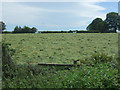
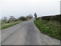
5

Crane Row Lane near Folly Farm
Looking westward.
Image: © Peter Wood
Taken: 28 Mar 2017
0.13 miles
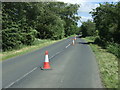
7
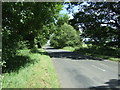
Crane Row Lane near Folly Farm
Looking east.
Image: © JThomas
Taken: 18 Jun 2018
0.15 miles
9
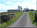
Crane Row Lane at the entrance to Newfield Farm
Looking eastward.
Image: © Peter Wood
Taken: 28 Mar 2017
0.23 miles
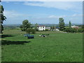
10
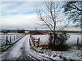
Folly Farm
Folly Farm with its approach road lightly snowed, as seen from the minor road to the south, Crane Row Lane.
Image: © Trevor Littlewood
Taken: 6 Dec 2011
0.24 miles