IMAGES TAKEN NEAR TO
Hamsterley, BISHOP AUCKLAND, DL13 3PF
Introduction
This page details the photographs taken nearby to DL13 3PF by members of the Geograph project.
The Geograph project started in 2005 with the aim of publishing, organising and preserving representative images for every square kilometre of Great Britain, Ireland and the Isle of Man.

There are currently over 7.5m images from over14,400 individuals and you can help contribute to the project by visiting https://www.geograph.org.uk
Image Map
Images are licensed for reuse under creativecommons.org/licenses/by-sa/2.0
Notes
- Clicking on the map will re-center to the selected point.
- The higher the marker number, the further away the image location is from the centre of the postcode.
Image Listing (5 Images Found)
Images are licensed for reuse under creativecommons.org/licenses/by-sa/2.0
Image
Details
Distance
2
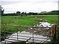
Pasture Land
A large sheep pasture, looking towards Edge Knoll Farm
Image: © Graham Scarborough
Taken: 21 Jul 2007
0.04 miles
3
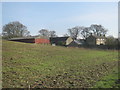
Field near Edge Knoll Farm
The field and Edge Knoll Farm are both close to the River Wear which lies in the trees beyond the field.
Image: © Trevor Littlewood
Taken: 27 Jul 2012
0.11 miles
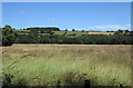
4
Cattle grid on farm road towards Edge Knoll Farm
Image: © Peter Robinson
Taken: 17 Feb 2013
0.20 miles
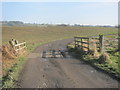
5
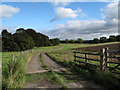
Farm road east from Park House
The road runs generally E from Park House to Edge Knoll Farm part of which is in view. The cattle grid in the foreground seems to serve no purpose now, being largely earth-filled and vegetated!
Image: © Trevor Littlewood
Taken: 25 Sep 2010
0.25 miles