IMAGES TAKEN NEAR TO
Aviemore Court, DARLINGTON, DL1 2TF
Introduction
This page details the photographs taken nearby to Aviemore Court, DL1 2TF by members of the Geograph project.
The Geograph project started in 2005 with the aim of publishing, organising and preserving representative images for every square kilometre of Great Britain, Ireland and the Isle of Man.

There are currently over 7.5m images from over14,400 individuals and you can help contribute to the project by visiting https://www.geograph.org.uk
Image Map
Images are licensed for reuse under creativecommons.org/licenses/by-sa/2.0
Notes
- Clicking on the map will re-center to the selected point.
- The higher the marker number, the further away the image location is from the centre of the postcode.
Image Listing (5 Images Found)
Images are licensed for reuse under creativecommons.org/licenses/by-sa/2.0
Image
Details
Distance
1
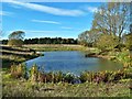
Pond beside Feeder Road to A66, Darlington
One of two ponds on rough ground beside a feeder road to A66.
Image: © Paul Buckingham
Taken: 25 Oct 2010
0.14 miles
2
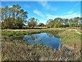
Pond beside Feeder Road to A66, Darlington
One of two ponds in rough land adjacent to feeder road to A66
Image: © Paul Buckingham
Taken: 25 Oct 2010
0.15 miles
3
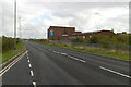
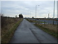
Darlington Eastern transport Corridor near Lingfield Point
Image: © Mark Anderson
Taken: 17 Oct 2020
0.18 miles